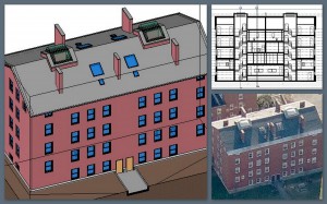
While I don’t usually take the time to pump my own gas with this blog I wanted to share the complete reversal in our deliverables over the last year. It used to be, way back at the end of 2008 that we delivered most of our building surveys in 2D AutoCAD format, now we would build in 3D, normally in ADT but our clients wanted 2D AutoCAD. From a surveying perspective a 3D object oriented universe worked better for us because essentially all the views were coordinated, that is build it in the floorplan directly, it is represented in elevation correctly. Anyone who has keyed up a plan in 2D knows where I am coming from, which if you are here reading this, means you know what I am talking about. Now, however, the bulk of what we do is deliver as-builts in Revit. The GSA requiring BIM has a lot to do with it, I believe, and Autodesk being the biggest player in the US means Revit becomes the default. Whether you like that or not does not matter, that’s the reality.
 Recently we have performed as built surveys at Phillips Exeter and Emmanuel College and we were field testing our laser to BIM technology, PKNail. It was created to capture typical conditions quickly and accurately. If you wanted to capture the Capitol Dome, I would suggest laser scanning, for capturing most situations Point to Point Laser Scanning (PPLT) should work just fine. PKNail converts measurements directly into a Revit workstation-wirelessly, measure a wall that wall is entered into Revit, encounter a door, window, Fire Extinguisher Cabinet, sink, if you can measure it, it can be placed quickly and easily into the model.
Lastly, if the deliverable is 2D CAD, exporting views from Revit to AutoCAD sheets is a snap. Here’s a long winded Autodesk treatise on the subject or well, it looks like I will need to update with a screen capture video the quick process but the resulting CAD contains some of the meta information collected in 3D, such as 30″ Door, rather than creating anonymous objects. Next post will follow in short order with a sneak peak of some of the features and the connectivity between Revit and a Leica Disto enabled by PointKnown surveying software.
Thanks for tolerating some self promotion.

