Posts Tagged google
3D Capture and Use : Not even at the Pong Level…..Yet
Posted by Jim Foster in 3D, New Technologies on November 17, 2014

We are still at the bleeding edge of the 3D capture technology. Even though LIDAR has been around since the early 60’s, commercialization of it remains small. Its projected market for 2018 is $515 million. What does that tell me? That’s ridiculously low. For perspective Facebook’s market cap is around $200b, EA Sports, the game producer for ubiquitous gaming technology is around $12b. Those are single companies not an industry. The total market for LIDAR, that is 3D capture of real objects is going to be $515M in 2018. Something else needs to happen to bring 3D to the main stream, and what’s happening now is the introduction of light weight inexpensive 3D sensors from a who’s who of technology companies. A partial list and by no means exhaustive.
- Intel Real Sense Technology
- Project Tango from Google
- Structure io
- Kinect from Microsoft
- Paracosm
- Meta io
- Autodesk 123D Catch
- Acute 3D
- Photosynth
- PrimeSense – Acquired by Apple
And from the way back machine:
Pong, the granddaddy of all video games was arguably the first commercial/consumer success of the gamification of a piece of hardware and its enveloping logic, in the case of pong it was TTL (Transistor – Transistor Logic ). So what’s important to note here is the players now involved in the introduction. Intel, Google, Microsoft, Apple…….. We have the introduction of the hardware and their SDK packs for developers. The next stage will be most interestin; .the software, the games, the apps, the big easy. The other technology beyond these new sensors and LIDAR in most use; photographs. Right now I see in the market a lot of people taking pictures of statues or people, turning them into a 3D Digital object and then maybe printing them out on a 3D printer, I don’t see that as a viable business model, personally I don’t want a 3D printed object of anyone I know and to me it borders on ventriloquist dummy creepiness. However, we need to go through these stages to get to whatever breakthroughs and or commercial successes there will be in the future.
3D printing is moving rapidly, if not into the mainstream, into real uses. The 3D printing market is estimated to be $16.2 billion in 2018 comapred to $2.5 billion in 2013. That is 30x the expected LIDAR market. Why? Companies are printing machine parts (cars, airplanes, etc.) there is movement toward biological printing of food/meat and body parts. So really the mass customization of things where before making one of anything could cost thousands of dollars. I recall prototyping parts through CNC machining or SLA cost at a minimum hundreds of dollars and for bigger parts easily thousands and up. At back to school night this year they had amakerbot set up in the High School lobby and would print out key chains with your initials for a $5 donation. Holy What? Really? How about 3D printing a partial titanium skull to help someone after the original was smashed in an accident. But 5 bucks for a custom printed 3D object?
So what’s the next step in the 3D scanning world now that people can start getting them in their hands for hundreds of dollars, opposed the LIDAR systems that start around $50K. You and your friends scan your house and drop it in as a map pack for Call of Duty. 3D virtual tours of the Louvre. 3D estimating of car damage…….I’m really not sure but I am sure there will be plenty of people working on it. Making the capture and use of 3D easy, that will be the magic trick. Why you might want to is a bigger question. What do I need 3D data for? For real estate? Who is ever going to buy something without physically seeing it. To quote a commercial broker when I was doing some biz dev, “I get them in the car and show it to them…” Remember the broker business is intensely personal so A) they want technology to help them not replace them and B) I am not sure having great 3D imagery is going to sell it. Maybe as part of the tenant fit out allowance they get 3D Design services, or as part of the negotiation you show them what it could look like with their allowance…..I would be really interested in what people think about this subject beyond it’s cool.
****
For something cool, check out the video posted for Mok3 above, Yonald and his cohorts had figured out a way in 2003 to take pictures and turn them into 3D environments., the world is still catching up.

Handheld Scanning for Architecture Gets Real….Google Enters The Picture
Posted by Jim Foster in 3D, New Technologies on March 4, 2014
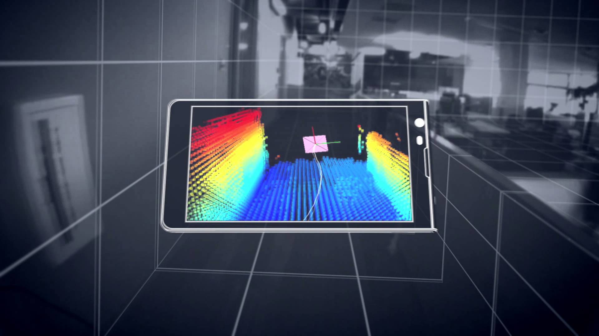 The jigsaw pieces are starting to fill in with google’s Project Tango , and the structure.io sensor. Capturing existing buildings has never been an easy task, as much as the purveyors of existing scanners would like you to believe otherwise. Current laser scanners are expensive and the process was usually too much, too much effort, too much expense for most projects. Additionally, since the entry price was so expensive and each scanner has its own proprietary software, lack of open standards slowed innovation; but here comes handheld devices starting at around $400, and an open source universe that lets a universe of people to start working on current problems. Paracosm working with Project Tango looks like it has come up with a crowd sourced platform to put together fuller models of buildings from multiple people/scanners.
From the videos and data, and although everyone admits it’s early. A regular Joe can walk with a handheld scanning device and capture their world. Allowing for the crowd sourced, user generated 3D mapping of the world. Besides the eery feeling that the Matrix was more prophetic than fiction what can be done with all this cool stuff, what’s next?
It will be in the processing of this data and digestion of it that will make it launch to the next steps. Typically the hurdle of laser scanning is going from scanned data, to data that people can use. Think of scanning this stuff….cool. To floorplans and 3D walk throughs for realtors. So if a realtor can take a $300 handheld scanner, walk around a home or apartment, and have it simply turned into a walk through tour and dimensioned floor plans of a home, excellent. Share those floorplans with a carpet installer for a price, great.
Before scans and point clouds were expensive to attain it looks like the price is about to drop dramatically. Dramatic price drop, easier to attain, increased supply. Increased supply, bigger market. Bigger market, more people. More people, more better. We are just at the start. There will be a lot of companies starting to fill in ways on how to capture and deal with this data and since the world spends about $8 trillion on construction alone there will be room for players. You’re invited.
Google X : Project Genie : Vannevar Technology -> Wants to Change AEC, Change the World
Posted by Jim Foster in BIM, New Technologies on November 4, 2013
 There seems to be little known about what’s going on at this century’s Xerox PARC, Google X and it’s Project Genie, but a small amount of information was unveiled at ArchDaily. Google’s commitment to sustainability is apparently going to reach into the AEC industry and possibly trample into Autodesk’s campsite. While other software firms are hampered by their own internal growth and sales and what they can commit to marketing, (Autodesk wins there) and R & D. The folks at google, know no such bounds. The spinoff Vannevar Technology (which sounds suspiciously close to Vandelay Industries,) is working on creating…..who knows. Their website states “Reimagining building design for a more sustainable future.” Which is about as exciting as the 5th slide in a time share deck. However, google has the clout and cash in what can be a very stubborn, hesitant to change,” what are you talking to me ” culture. Typically the principals in architecture firms don’t care about technology, they have minions to get it done so why invest in software or new tech when my current pricing, business structure, ROI formulas are working and set in stone, plus I don’t like business that much I like designing building so the less I get involved the better. Engineers will analyze and without comparable metrics to analyze, then…paralyze. Construction managers will embrace tech if it saves the time, which equals money, so time and money but they have to live with the consequences, so embracing new tech….tough crowd. Which is far from saying that things can’t be done better.
The small bit of copy on the web site rightly touts that buildings, yes buildings produce the most greenhouse gases, 40%, so what is google going to do about it? Systems, software, construction methods, materials, vertically integrate and go borg on the industry. My guess is whatever they do, they will be building some buildings with Vannevar Tech for proof of concept and case studies. My guess it’s got be some integrated design and FM system to produce tangible CO2 / greenhouse gas savings, plus energy savings. Some have guessed it might be a SketchUp on steroids, but then why did they sell it to Trimble. And who cares about the design process, what part of that is the current lifecycle of a building, very little, I’d want to own the building for most its life, it’s operating life, and want to own the management of it, and the data. There ya go, so then, IBM and Maixmo, meet google, you might know them. These are the crazy kids floating balloons for internet access. 
Holy Frijoles: Trimble acquires SketchUp : Game on to own Digital Buildings
Posted by Jim Foster in BIM, Built Environment, New Technologies on May 2, 2012
 As they say on Sport Center, Trimble is en fuego, they acquired Tekla earlier with a well documented, well established player, especially in the structural space who also released their own BIM product with BIMsight, and now they are acquiring Sketch Up. While all the SketchUp users are asking, ‘who the hell is Trimble?’ The Trimble folks, or AEC folks understand. Looks to me that Trimble is vertically integrating and surrounding the ‘digital’ building. Someone said to me somewhere along the line that “Leica is an engineering organization that has to sell stuff. Trimble is a sales organization that happens to sell surveying equipment” Anyway you get the gist. Makes one wonder what Autodesk will counter with now that Trimble has crashed the party. Seems like Google has decided to give up the building data market and concentrate in collecting every piece of information that exists about individuals instead. That’s too bad because it would have been interesting to see the Google Machine start to digest all that building data. However, the fact alone that they had 30 million activations in the past year has to give anyone in this space pause, then again it’s free, but free works for market penetration. And honestly isn’t the end game to get a project into your ecosphere and manage it from design to demolition, from cradle to grave and Trimble is starting to put together a pretty compelling environment. Let’s take a look shall we:
Accubid – Cost Estimating Project Management Software : CAD based or screen take offs (acquired by Trimble August 2010)
HHK – GIS and CAD Surveying Solutions For Germany and Europe. (acquired by Trimble January 2008)
Meridian – Capital Projects and Major Renovation Management Software (acquired by Trimble October 2006)
Plancal -HVAC , Building equipment and Appliance Software (acquired by Trimble January 2012)
QuickPen – Provides Pipe and HVAC Estimating Software Solutions, CAD Detailing Solutions for HVAC and Mechanical Systems (acquired by Trimble March 2009)
Tekla – Building Information Modeling (BIM) Solutions (acquired by Trimble
Trimble Business Center – Allows you to edit, process, and adjust data from all Trimble surveying instruments from your desktop
Trimble Connected Community– Web based project management, let’s just call it the “Cloud” based management, at least they should.
So what’s all this Vertical Integration mean? Well Rockefeller or Carnegie would argue it creates efficiencies in the market place, offering you a better product for less money. However, I am more curious to how Autodesk responds. They could argue that Trimble is not a threat because they “Autodesk” are a 3D company, not just focused on AEC. It reminds me of quote from Bob Rosenberg, former CEO of Dunkin Donuts when asked about Krispy Kreme’s rise. This was at a time when Krispy Kreme was hot and expanding everywhere. CEO Rosenberg responded, “we don’t see them as a competitor.” To which you might say, are you kidding me, “DONUTS”, but he followed with “we’re a coffee company they’re a bakery.” And you know what, he was right, but we’re talking about the ownership of buildings in the digital domain, that’s big.
So we see a hardware company, Trimble, acquiring a lot of software. Would Autodesk start to acquire hardware. Although back in the day one of their product managers told me, “we don’t do hardware.” I expect to see more acquistions down the road. FARO, a publicly traded company at about $1 billion could be interesting. Where are the gaps in the portfolio? What’s next?
Pretty Sweet 3D : Nokia Launches Ovi : Wants be your new map destination. #GIS #3D #BIM
Posted by Jim Foster in 3D, GIS on April 27, 2011
 Thanks for Bruce Lang for bringing this to my attention. Browser Plug In to Navigate the Earth, many cities are in 3D, I quickly browsed the East Coast and both Boston and New York look pretty sweet. Utilizing technology from C3 and from their blog:
C3 uses modern camera equipment to capture as many as one image per second of the same object from up to 100 different angles. The images are then used to automatically reproduce the shape of the objects with very high accuracy. After that, an image processing software automatically drapes each shape with the texture chosen from the pictures of each object. The same process is being applied for all objects – buildings, houses, trees, and hills – the result is a seamless canvas of 3D-data where the resolution (8 to 12 centimeters per pixel) and quality is consistent over the entire model. This is the secret to C3 maps’ realistic look compared to competitors’ hand-made and cartoonish appearance.
You can get the plug in here. Understand that the photo is screen shot from the product, you can spin it around change perspective, go around the building to the other side, sweet.
However, Why? Think of it this way, how many times do you use google maps, or live maps, in a week, in a day, to navigate, to check something out and then think of all the ways I can sell you stuff if you are using/looking at my map? So if I have better eye candy to get you in my store, so be it. Not like Nokia is a small company but certainly like to see people swinging at the hegemony. And did you notice the comment ‘competitors handmade cartoonish appearance.’ Who you talkin about Nokia.
Google now to Digitize the Earth and Every Building On it : #BIM #GIS #3D
Posted by Jim Foster in Uncategorized on April 26, 2011
 So trying to digitize every book, and mapping every street was not enough so Google (GOOG) has now gone after the earth and all its GIS data. Matt Rosoff of the San Francisco Chronicle Reports, “Google Attacks Huge New Market with Earth Builder” Google is stretching its brawn into specialized verticals that use to cost $millions to play in.
However, if you look at Autodesk and how it has started to push what they are calling “Reality Capture” and the energy modeling of the existing environment you understand the play. Additionally, existing buildings are the biggest consumer of energy out there and the first to really to look to identify savings and efficiencies, there is a movement toward 20 by 2020, that is 20% increased efficeiny in commercial buildings by 2020, and capturing/modeling/retrofitting, etc. all part of it. Well, I’m getting a little bit off topic, let’s repeat the SF Chronicle Headline, “Google Attacks Huge New Market”. Google starting to frighten anyone yet?
Pointools plugs in SketchUp : Use Point Clouds directly inside SketchUp Modeling Environment : BIM
Posted by Jim Foster in 3D, Built Environment on November 30, 2010
 Interestingly enough, while at Autodesk University, Pointools announced their plug in available for SketchUp. Make the jump to read all about it, but I guess with this announcement maybe the next thing we’ll see is the Google car with a scanner on top instead of just a camera. Google and Autodesk are now squarely in the same ring.
