Posts Tagged reality capture
Pointknown Wraps Up 18 Tremont : Building Surveying & Documentation : Direct to Revit
Posted by Jim Foster in BIM, Built Environment, Revit on February 8, 2016
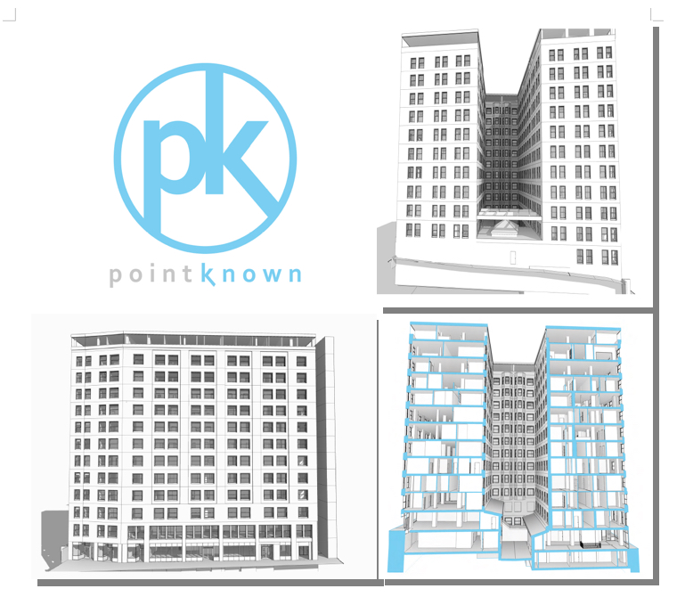
We recently delivered a Revit EB (Existing Building) Model of 18 Tremont a historic 12-story, 202,000-square-foot office with ground-floor retail in downtown Boston. The building was acquired by DLJ Real Estate Capital Partners in October 2015. Pointknown, with its partners, created an exterior HDLS (High Definition Laser Scan) and Revit model of the exterior as well as the elevator lobby, and stair cores. After creating the base Revit model the Pointknown Team utilized PKNail Pro , a point to point, direct to Revit, reality capture tool, to document interior wall partitioning, doors, and bathroom layouts. Using the combined technologies helped us tremendously in speed and accuracy, and the database functionality of Revit allowed us to assign spaces/offices and run space calculations a lot easier than polylining spaces. We were then able to produce formatted documents, floor plans, sections, space calculations for the owners / investors and delivered the model for the designers.

Reality Capture, for Real. Autodesk Completes Capture of Allpoint Systems : #BIM
Posted by Jim Foster in BIM, Built Environment, New Technologies on February 7, 2013
 At the end of this month Autodesk announced it completed the purchase of Allpoint Systems, this adds to the ‘Reality Capture’ stable now including Alice Labs. Although much like the borg, you google Alice Labs and not much comes up as the technology and seemingly most of the talent has been absorbed into the mothership. As with the purchase of Alice Labs it does not appear that anything from Allpoint will be available for purchase anymore as the technology is incorporated into existing Autodesk products. From the Press Release:
The acquisition of Allpoint Systems reflects Autodesk’s continued investment in developing sophisticated, easy-to-use reality capture technologies. Reality capture is the practice of creating digital models of physical objects and spaces using photography, laser scanning and other technologies.
Why ‘Reality Capture’ or the ‘Documentation of Reality’, well let’s talk about cars, hang with me. According to our good friends at Wikipedia, there are about 254 Million passenger cars on the road or registered in the United States and compared to new car sales of almost 13 million that’s a rough ratio of 80/20, that is new versus used. Interestingly, last time I pulled numbers and the Boston Redevelopment Authority of new construciton permits vs permits for improvements etc. in existing space it was 80/20, in favor of the existing space. So, look where the work is done, used cars, maintenance, improvements, after market, selling gas, same for buildings, infrastructure (bridges, tunnels) etc. And the best way to start a project is to document building, bridges, etc. accurately. The smart money buys used. Or let’s have Autodesk PR Recap. “….continued investment in developing sophisticated, easy-to-use reality capture technologies”
Autodesk digging into the Built Environment : Augments ‘Reality Capture’ Stable by acquiring Alice Labs
Posted by Jim Foster in 3D, BIM, Built Environment, New Technologies on October 18, 2011
80/20, the amount of construction projects that happen in the built environment vs. new construction, at least here in Boston and this is usually the case across the globe, maybe not 80/20 but having the majority of construction happening in the built environment. So if you’re Autodesk and you have all this great software, you can no longer presuppose the data, you are going to have to capture it somehow.
Autodesk put another arrow in their ‘built environment’, ‘as built’ or soon to be trademarked “reality capture’ quiver by acquiring Alice Labs. As reported in Graphic Speak, Autodesk Scoops up 3D point cloud innovator Alice Labs. And if you go to the Alice Labs website, all you get is a splash page saying they have been acquired by Autodesk, and no press releases from Autodesk either. Why not? Autodesk is like the borg, well I can’t comment on the assimilation part, but as far as sucking up cultures within their universe, no problem. So why not let people know.
The small team, closely related to ongoing research at technical universities in Delft, Netherlands and Ghent, Belgium, has previously released Studio Clouds, an innovative 3D laser point cloud editing technology that offers plug-ins for Autodesk’s 3ds Max and Maya modelers, and uses a proprietary game engine for fast manipulation of point cloud data…Behind the application is the Mirage Nova Engine (MNE), said to be capable of handling billions of points with ray-trace visualization quality. NME also offers a photogrammetric tool, offering an affordable way to generating high fidelity point cloud models from photographs. MNE is designed for 64-bit multi-core architectures and can take advantage of graphic card acceleration for maximum speed. -Randall – Graphic Speak
Either way, Autodesk is interested in getting you working in their software whether it’s for new construction or the the built environment, designing retrofits or modeling New York for gameplay. If it’s a 3D environment they want to put you in it, and Autodesk wants to be the transporter…Kirk Out <end cheesy Star Trek word play>
PointKnown cited in Autodesk Energy Modeling White Paper : BIM
Posted by Jim Foster in 3D, BIM, Built Environment, disto on June 29, 2011
 Autodesk has been concentrating on incorporating their energy modeling tools into their workflow, so much so, they are now calling it Rapid Energy Modeling and have outlined a variety of ways to capture a building’s geometry digitally so you can run it through their energy modeling engines. They outlined the following techniques/methods as the most cost effective for capturing exisitng conditions. Full paper available here: rem_white_paper_2011
Digital photographs
These are photographs of your building taken specifically for rapid energy modeling.
Aerial images
You can download oblique aerial images from Internet sites such as Google Earth or Microsoft®Bing™ mapping services. Alternatively, you can use images from commercial providers of geo-referenced aerial and oblique image libraries such as Pictometry.
Satellite images
Like aerial images, you can download orthogonal images of your building from sites such as Google Earth. RAPID ENERGY MODELING FOR EXISTING BUILDINGS
Laser distance meters
These low-cost laser meters are common surveying tools, and you can also use them onsite to capture key measurements of your building.
PointKnown was cited as the software to use when utilzing laser range finders and capturing a building in revit.
If you plan to capture existing conditions using a laser distance meter, you can use PKNail software from PointKnown (www.pointknown.com) to process those measurements and create a Revit model of your building. By inputting a few simple field measurements PKNail will build a Revit model of the existing structure, in the field, in real time.
This approach involves trained survey personnel that walk around the perimeter of a building and measure key points on the building. The PKNail software utilizes Bluetooth®-enabled laser distance meters to capture dimensional data in the field and send it directly to a laptop loaded with the Revit Architecture or Revit MEP. By capturing data in a specific sequence, the PKNail software creates a Revit model representing the skin of your building as it is being measured.
While we wait for the ‘magic wand’ that digitizes existing buildings while you walk through it, and when I mean digitize, I mean scaled, architectural objects that can be scheduled, processed, etc. more and more technologies are being developed to speed the ‘realty capture’ of buildings. The argument for using PKNail is that the exterior model you build is natively in Revit Architecture and if you want to move inside for interior wall partitioning, etc. for adaptive reuse, etc. you can do that all by utilizing the key pad interface and the laser meter.
Not changing the world just making your day to day a little easier, increase productivity, get more accurate, teeing it up so you can knock it out of the park.
Reality Capture #2 on Autodesk Labs Hit List : Project Galileo to join other tools. BIM
Posted by Jim Foster in 3D, Autodesk, BIM, Built Environment, Point to Point Laser Technology, Revit on November 30, 2010
 As reported by Matt Ball, Brian Mathews, the Autodesk VP in charge of Autodesk Labs, gave a media briefing updating ‘his Seven Technology Trends lecture with example projects.’ Reality capture or as otherwise stated, turning analog into digital, being #2 on the hit list. So capturing the Built Environment is starting to get serious traction, and while I hesitate to use the word traction, well, that’s what its getting.
Previously in the conversation people would talk about all the wonderful things software can do for buildings, then you realize the majority of construction is in the built environment and it becomes, well just give me the building, or at lest the digital equivalent of the building and look at the wonderful things software can do, however, most presupposed the digital equivalent of the building. Not anymore, more and more companies are releasing software and tools to capture the built environment, or call it reality capture if you like, but soon there are going to be a lot more tools on your shelf.
Autodesk has released, Project Photofly . and will soon release Project Galileo which according to its splash page, “is an easy-to-use planning tool for creating 3D city models from civil, geospatial and building data, and 3D models.” Plus Autodesk has release shape extraction tools from PointClouds directly inside of AutoCAD. Rand Technology/Avatech/Imaginit hybrid has released PointCloud manipulation tools inside of Revit and we are in the final beta of PKNail, a PPLT (Point to Point Laser Technology) system that allows a user to drive Revit commands and enter dimensional data directly from a range finder allowing a user to build a Revit model in the field. Plus we recently saw the beautiful kinect hack allowing a user to capture and even measure 3D video. I can’t say which technology or mixture of technologies will work best for you, but your job is going to get easier.
PointKnown Nails It. Rapid Models Autodesk AEC HQ in Waltham: Pilot moves on.
Posted by Jim Foster in 3D, BIM, New Technologies on November 4, 2010
 So some individuals at Autodesk got to see our ‘handcrafted’ videos available at our PKLabs YouTube Channel and got in touch. Ani Deodhar, a Program Manager in their Sustainability Group, explained to me he had a mandate to come up with the best work flows across all of their product lines in order to energy model existing buildings. They have been working on geometry extraction in the labs and anyone who has seen the Photofly demos can attest, this looks very promising. However, our goal with PKNail was always to capture dimensionally correct space and do so with a minimum of software knowledge so PKNail can be leveraged across an organization rather than with a specialized few. I am not knocking any process just pointing out that if you want to move a pallet, for example, it would be nice you could just do it rather than find the guy or gal with the forklift license and then ask them to move it, and then hopefully you get it right the first time. Maybe not the best metaphor but you get it, the more people that can do something, the more of whatever ‘it’ is you can do.
 On site at Autodesk Waltham and using PKNail we were able to survey, measure, build in real time the shell of the building in Revit in less than 3 hours. Then depending on what level of detail, and features you want in the deliverable you may want to spend sometime in the office. However, when we left we knew we had all the key dimensions and information and the model itself was built. This was done at a level needed for energy modeling and we only modeled from the exterior but PKNail allows you to create interior layouts, floor by floor as needed as well. It was then ported through Revit CEA to create an energy analysis of the building.
When creating PKNail we wanted to make things easier on ourselves. The product grew organically from our architectural surveying business. When you’ve repeated the same task enough times, or if you missed a crucial step or measurement that would require you to back to the field, etc. you think there must be a better way. Just like when you make the jump from 2D to 3D you thought, there must be a better way to communicate with my clients, coordinate views, coordinate disciplines, and here it is. Revit is increasingly becoming that better way. Use it however you want, it’s a tool, you can use it communicate visually with your clients if that’s what you need it for or use it to coordinate construction; your choice but it helps. PKNail allows you to quickly and accurately capture existing buildings digitally, either just the exterior for energy modeling or to start your as-built documentation.
On a recent conference call to discuss our pilot with Autodesk, one of the attendees said something like this:
“So you simplified the GUI to automate the tasks you need when surveying and allowed for the wireless capture of data to minimize key stroking”
Well, I don’t know if I would say it exactly like that, but yeah, that’s what we did, and I added that we created a workflow and process that squeezes the surveying knowledge of our organization into the software so people can be a success right out of the box. We wanted to take something simple, point and shoot distance meters, very simple and marry it with something that can be infinitely complex, 3D BIM authoring tools as in Revit, and in turn try to make that simple. Measure a wall/build a wall, window, levels, etc. We call this PPLT (Point to Point Laser Technology). So until we got robots doing this stuff we can never take away the human element from what we do, and so, let’s make just make it easier, faster, better, much like the $6 million dollar man.
