SLAM and Drones and HDLS….oh my

SLAM and Drones and HDLS….oh my.

There seems to be new tech, and “reality capture” methods popping up on the daily. The lens that I look at it through though is how can any of the technologies and methods get us to a point quicker and more accurately. No, we’re not in Kansas anymore.

SLAM (simultaneous localization and mapping ) , these devices and specifically the ones developed by GeoSlam, was the first time I bought a demo and did not want the rep to leave my office with what he brought. The conversation went something like this “I’ll take it”. “Okay we can write you up and deliver….” “No I’ll take what you have in your hands right now, how much” and subsequently we bought another. As far as the combination of speed, cost and quality (granularity of data) I have found it pretty remarkable in what it does. It has its limitations though and why we augment SLAM data with other collection methods to get us to a better whole, and again; this depends on the scope of the project.

Many of you, certainly if you are reading this, are familiar with HDLS (High Definition Laser Scanning) which most people just refer to as LIDAR . Why make the distinction? Because LIDAR really is the big tent, laser scanning as a whole, and all the machines, processes are the acts. HDLS typically requires individual set ups, the machines stay stationary and the process while slower and more cumbersome still produces the highest density of data. To help explain this I’ve come up with possibly a slightly less confusing metaphor or perhaps no help at all. Steam, water and ice. With steam water in the gas phase and it’s molecules are far part, relatively speaking, water, liquid phase are tight, and ice, water in solid form the molecules are tighter yet. With scanning the density of the points, like water molecules are tighter or farther apart based on the technology you are using and why we need to use different ones based on the scope of the project.

In the images I have included, the first one is created through HDLS using tripod mounted stationary FARO Focus. If you zoom in, you can see the handles on the cabinets, the images in the painting, etc, this is because the machine takes photos as part of the process, at least in this case) and maps them to the collected points, giving us a true 3D representation of the space, which is the back of a theater by the way.

In the second I have included both the SLAM cloud and HDLS together, you can see where the SLAM backfilled around the objects and the cabinets, giving us data to model from, the extents of walls, heights and profiles of objects, etc.

The last is solely a SLAM cloud, I can tell what and where the objects are but the cloud is just a mass, no photos, and the details/density would not allow us to determine, let’s say, the cabinet handles. Do you need definition of handles? Or in most cases of documenting existing, do you just need a volumetrically correct model that looks good in elevation and model view. We’ve completed projects where the client wanted a 3D database of almost everything because they were retrofitting an HVAC package into an existing and very significant building. They wanted to A) document everything properly and B) be able to fabricate any objects from the data in case they were damaged during construction. This was obviously a case where we needed to create high def scans through out the entire building, in classrooms though, which did not have significant architectural detail we used our own software, PKNail, to create the geometry. It’s the ability to blend technologies and capture methods that allows a service provider to best serve the client from a detail and budgetary point of view.  After you’ve completed the data collection, made sure all the data is registered to each other, even from disparate sources, that is SLAM with HDLS, with Drone captured data, etc. you’ll need to choose whether you want Revit or Autocad…but that’s an entirely different conversation, however, more times than not when using these technologies together you are creating a robust 3D data base of the building that can be revisited for any questions or even new documentation needs.

PRO CON
HDLS Best granularity of data. Point density. Almost all machines are stationary so every shot needs to be set up and registered. Although software advances have helped in automation. Slower process.
SLAM Quick, captures data at walking speed. Decent density for details and over all dimensions. Covers areas well where it has range. Limited range. Occasional hiccups and data “drift”
Drone Quickest, Exterior Only, great for massing and building geometry. Capturing data in hard or inaccessible places. Captures hi-res images of project. Limited data density to pick up details. Object distortion.

Pros and Cons of SLAM / HDLS / Drone ©Pointknown 2018

Below are some screenshots that will put most to sleep but if you’ve read this far, maybe not. The large one is of combined clouds (HDLS / SLAM) of a building we completed in LA.  They were registered together, and rendered in Revit / ReCap.  The first of the smaller ones is a close up of a wall with just the SLAM cloud. The second is the HDLS data overlaid the wall in Revit, the last is just the data. You’ll notice how tight the HDLS Line, with very little spread between the data points. The SLAM data looks faded in comparison and the “spread” between the farthest data point and closest is about 1/2”, that is the HDLS line looks like it was drawing with a ball point pen, the SLAM with highlighter. Experience in dealing with both sets, pro and cons can help.

Share

, , , , , ,

No Comments

Get in the pool! Historic Santa YMCA Begins Its Journey to Return to the Community.

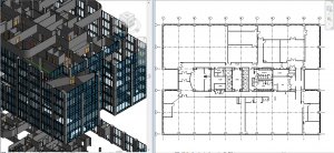
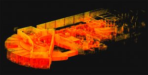
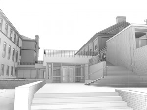
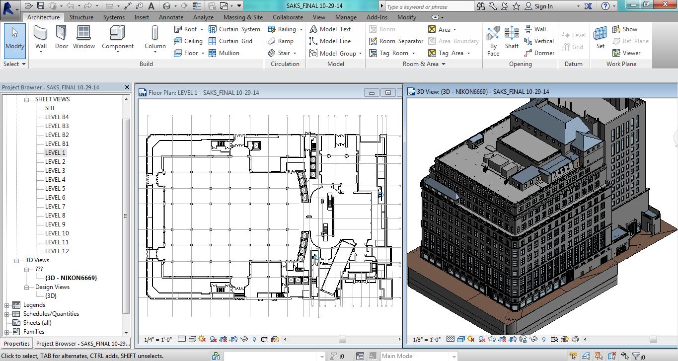
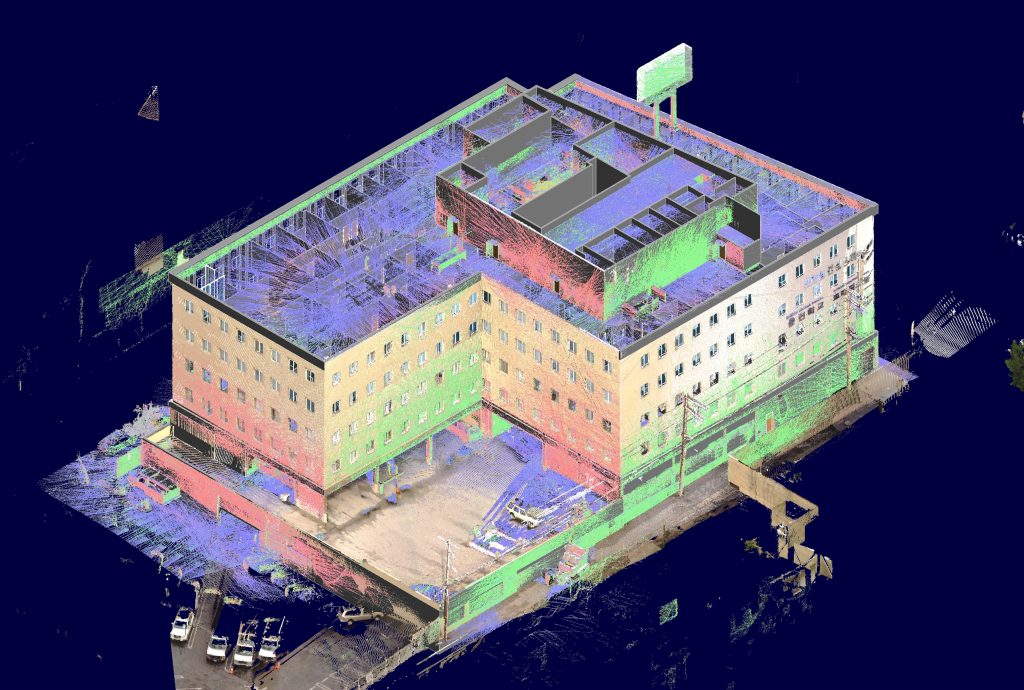
Pointknown tasked with creating a Revit model of an existing YMCA in Santa Ana CA utilized a variety of technologies to capture existing architecture on site. We used a FARO Focus, GeoSlam ZebRevo, Leica Distos and our own PKNail software. And grit, and coffee, and ladders.

Hi Jim, The model is fantastic… 1st Six Words Upon Delivery of our Santa Ana YMCA Revit Model

Troy Fosler – Koning Eizenberg

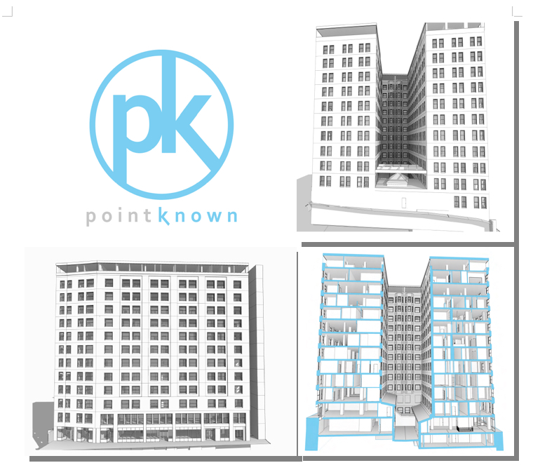
The historic YMCA located in the heart of Santa Ana abandoned over twenty years ago is set to go under a massive rehabilitation and afterwards be returned to the community.

The proposed renovation of a landmark YMCA built in 1924 will restore the building’s role as a central anchor in the community of Santa Ana. The project aspires to influence positive lifestyles through wellness & fitness programs designed for a variety of local stakeholders.

Having been involved in hundreds of renovation and reuse projects, it’s awesome to be part of one that can have such a huge impact on an entire community. Good on ya Santa Ana I’ll see you in the pool.

Share

, , , , , ,

No Comments

300,000 SF in less than 12 hours.

delaware_bldgBuilding on my earlier SLAM post, we’ve been utilizing the combination of SLAM and PKNail Pro to great success.  Recently we completed over 300,000 SF of office tower in Wilmington, DE with the total time on site coming in just under 12 hours, yes that’s right 12 hours.  The scope of the project included BOMA reporting and CAD, and while the parking garages were not initially part of the scope, we walked the garage with SLAM so had a 3D database in case it was needed in the future, and in this case, it was needed in less than a week and we did not need to revisit the site, saving the client both time and money.

Process: Walk each floor with SLAM, create 3D database by floor.  Build out interiors, sample floor, with PKNail Pro, capturing typical window assemblies, doors, plumbing objects, wall thicknesses.  Back office included the combination of surveying data, creating spaces within Revit and exporting both spreadsheet data, CAD and plotted floor plans.


Share

, , , ,

No Comments

SLAM : A Revolution in Building Surveying & Documentation


buildingslamSLAM technology. SLAM, besides sounding rather cools stands for ( Simultaneous Localization and Mapping). And this is is an evolution in the creation of point clouds.  Why? SLAM technology allows a user to walk through space, and in essence, create a continuous point cloud of an entire space.  Previous technologies require a machine to be placed on a tripod, and continually set up in different locations.  To get a full ‘picture’ of whatever you are scanning separate scans  have to be ‘stitched’ together, which is not as automated a process as you might imagine.   While Leica continues it onslaught of proprietary products and continuous scanning with its Pegasus systems, SLAM is based on open standards and researched extensively through the robotics industry.  Off the shelf technology in the form of Hitachi Lasers, Rasberry Pi Processors and the like will start to open up new devices and allow new manufacturers to enter what has been a highly technical and closed field.

While SLAM devices do not have the high fidelity of HDLS, it does allow for some pretty excellent data collection that is typically at a level needed for most building documentation, leaving highly specific / detailed tasks for the more heavyweight scanners, think exposed and extensive MEP, physical plans, historic documentation/reconstruction.  Personally, using SLAM devices in combination with our PKNail Pro allows us to move through spaces quickly, efficiently, accurately capturing building geometry with both systems and creating dimensionally accurate Revit objects on the fly with PKNail Pro.    This allows us to get in and out of space with minimal interruptions, and allows for quick turn around which is great for building owners/investors through due diligence, BOMA calculations or looking to repurpose/reprogram a building.  Recently, we were in and out of 300,000SF of tower in Wilmington Delaware in less than 36 hours.

While SLAM allows for the quick collection of data, interpreting, understanding the data and turning the data into usable documentation still remains very much a craft process.  Too many times I have seen a product, such as a Revit model, turned out by groups who fail to understand how building are put together and designed which eventually turns into a product that confuses and confounds the people/architects who need to use it.   In the next post I hope to dive into this process vs. product a bit deeper.

Share

, ,

No Comments

EXISTING BUILDING SURVEYING : POINTKNOWN DOCUMENTS OCEAN SPRAY HQ

PK Ocean SprayPointknown was tasked with capturing Ocean Spray’s HQ, over 160,000 SF of Office Space and Labs over 3 Floors  set on  hundreds of acres of woods and bogs in Lakeville, MA.  Because of the nature of the building and deliverable we were able to capture the bulk of the features and geometry directly with PKNail Pro, allowing us to measure and model in real time in the field.  Interior Wall Partitioning, Bathroom Layouts, Windows and Doors.  After the geometry was completed we placed the acoustical tile grids, and placed objects directly with the Revit interface.

For surveying and documenting buildings having a set of tools allows a provider to offer the right solution set to your clients.  Not everything’s a nail so carry more than a hammer.  We first developed PKNail Pro because we needed another tool set in the field, and started offering it commercially because clients asked us if we would provide it.  Does it do everything, no; it was intended and designed to capture typical conditions very well, and quickly by turning measurements directly into Revit based objects, walls, windows doors, locate / place wall based objects from plumbing to electrical to fire protection and it does that very well.

Quote of the Project Upon Early Arrival and Hearing Barking/Howling:  “No…those aren’t dogs, those are coyotes.”

Share

, , , ,

No Comments

Pointknown Wraps Up 18 Tremont : Building Surveying & Documentation : Direct to Revit

18 Tremont     


    We recently delivered a Revit EB (Existing Building) Model of 18 Tremont a historic 12-story, 202,000-square-foot office with ground-floor retail in downtown Boston. The building was acquired by DLJ Real Estate Capital Partners in October 2015.  Pointknown, with its partners, created an exterior HDLS (High Definition Laser Scan) and Revit model of the exterior as well as the elevator lobby, and stair cores.  After creating the base Revit model the Pointknown Team utilized PKNail Pro , a point to point, direct to Revit, reality capture tool, to document interior wall partitioning, doors, and bathroom layouts.  Using the combined technologies helped us tremendously in speed and accuracy, and the database functionality of Revit allowed us to assign spaces/offices and run space calculations a lot easier than polylining spaces.  We were then able to produce formatted documents, floor plans, sections, space calculations for the owners / investors and delivered the model for the designers.

PDF Images

Share

, , , , , , , , ,

No Comments

Top 3 Issues : Revit Models for Existing Buildings

PEA_Academy_Arts_Building

Phillips Exeter Academy and Arts Building

In my experience through a dozen plus years of the topic, these issues are best discussed and defined at the outset whether you’re outsourcing the work or doing it yourself.

  1.  What is the initial use of the model?

Start with a MVM  (Minimal Viable Model ), volumetrically correct and add detail from there.  Interior designers will need different detail than someone implementing CAFM tools, then will an architect adding an addition or an adaptive reuse project.  Custom windows, Wall Types, Beams, Fire Protection, Molding, etc. can all be added later so don’t pay for what you don’t need.


  1.  What technology is being deployed?

There are a variety of technologies out there, what are you or your vendor using?  How much experience do they have.  Do not be afraid to ask for or create a technology road map and ask for demonstrations, experience, and documentation of previous projects.   Technology and data capture can be and should be quite different for a 1000 rooms in a hotel vs. a theatre with non-orthogonal walls, balconies, and lots of trim detail.  Will it be HDLS (HIgh Def laser Scanning),  PPLT (Point to Point Laser Technology or P2P), Photogrammetry, Hand measuring and graph paper? There are price considerations to be had with each.


  1.  Architectural Intent?

Hard to believe this makes into the top 3, however, you need to discuss how you want to deal with non-conforming issues.  For example, less than a .3 degree deflection of a wall in plan view will cause +6” over 100 feet.  Who cares?  Do you?  It’s important.  As non-ortho connections in Revit cause model errors, something in new construction Revit wants you to avoid, however when modeling existing not every building was built perfectly square.  Would you rather see the building modeled with regards to architectural intent and have any non conforming issues annotated or do you want it modeled as it exists.  
There is a lot of confusion in the marketplace with regards to laser scanning and modeling existing conditions as there are no standards in place, nor certifying boards for anyone doing this work so until that day happens the onus is on the consumer to ask the questions and help manage the process to get the model they need.

Jim

Co- Founder / CEO Pointknown

Pointknown provides services and software for documenting existing buildings in Revit.  We also offer consulting to set up your own projects through enabling technology or project management.


Share

, ,

No Comments

AEC Alliances, Purchases, Cats Living With Dogs

staypuftLike a ship that has long passed ripples from Apple’s long held strategy to combine software and hardware has finally come to shore in the AEC marketplace when Autodesk recently announced a ‘collaboration’ with Leica.  This shatters their long held belief that they would “never partner with software.”  Straight up from the copy on their splash page.

“Smart integration empowers our customers to construct more efficiently and more accurately by making design and reality fit together.”

I have to say this has been a long time coming because if anything Autodesk is excellent at marketing and mostly sort of listening to their customers and marketplace something Leica is beyond woeful at.  They are a classic engineering company who makes great products and convinced of their products greatness believe it will have a market.  I wonder if they have ever in their existence put together a customer focus group.  While Autodesk continues to partner and acquire multiple companies in the 3D and Built Environment space Faro, Leica’s main competitor, acquired Kubit in March.  Trimble now owns Tekla, Sketh Up and Gehry Technolgies . 

What does the Leica / Autodesk union mean?  I would think at least when you need to export point for layout, instead of just picking a generic export you would then export to Leica’s family of products as an option.  Perhaps Cloudworx and Recap combination, as I would believe if you are firing up a Leica scanner, their would have to be some link directly to the Autodesk family.  Is this friendly oligopoly good for the industry.  Well when Windows dominated the marketplace people argues their monopoly was good as it provided a defacto standards, just like Rockefeller argued Standard Oil’s position of owning everything allowed for efficient pricing.

Share

No Comments

Pointknown / IR Captures and Models NYC Building Icon in Revit

Pointknown / IR captured and modeled the Saks 5th Avenue Flagship building over the summer.  The building, located at 611 5th Ave NYC,   was just refinanced and according to the New York Times valued at $3.7 billion dollars. That’s over $1 billion more than Royal Hudson paid for the entire company last year.   The survey and modeling teams used a variety of technologies including LIDAR,  its own PKNail Pro and Revit from Autodesk worked throughout the night so not to  disturb its clientele and associates.  Working through Rob Siegel, now the Design Director at Gensler Pointknown / IR created a full exterior model, shell and cores including the mechanical penthouses.  Said Rob, “This is one of the best models we’ve ever seen.”

Pointknown and its sister company IR (interioreview) creates software for the capture and modeling of existing buildings, and provides the same as  a service.  It uses best in class technologies, whether off the shelf or custom software it designs itself.  The companies are entrusted with documenting buildings like Saks 5th Avenue,  the Royal Sonesta in New Orleans , academic building on UMass and Phillips Exeter campuses to your home.  This December it will be continuing its work as part of the Phase III renovation of the Chicago Hilton.  What can we help you with?

*******

Pointknown

support@pointknown.com

617.575.2222

SFA NYC


Share

, , , , , ,

No Comments

3D Capture and Use : Not even at the Pong Level…..Yet

tsp-pong

We are still at the bleeding edge of the 3D capture technology.  Even though LIDAR has been around since the early 60’s, commercialization of it remains small.   Its projected market for  2018 is $515 million.  What does that tell me?  That’s ridiculously low.  For perspective Facebook’s market cap is around $200b,  EA Sports, the game producer for ubiquitous gaming technology is around $12b. Those are single companies not an industry.  The total market for LIDAR, that is 3D capture of real objects is going to be $515M in 2018.  Something else needs to happen to bring 3D to the main stream, and what’s happening now is the introduction of light weight inexpensive 3D sensors from a who’s who of technology companies.  A partial list and by no means exhaustive.

And from the way back machine:

Pong, the granddaddy of all video games was arguably the first commercial/consumer success of the gamification of a piece of hardware and its enveloping logic,  in the case of pong it was TTL (Transistor – Transistor Logic ).   So what’s important to note here is the players now involved in the introduction.  Intel, Google, Microsoft, Apple……..  We have the introduction of the hardware and their SDK packs for developers. The next stage will be most interestin; .the software, the games, the apps, the big easy. The other  technology beyond these new sensors and LIDAR in most use;   photographs.  Right now I see in the market a lot of people taking pictures of statues or people, turning them into a 3D Digital object and then maybe printing them out on a 3D printer,  I don’t see that as a viable business model, personally I don’t want a 3D printed object of anyone I know and to me it borders on ventriloquist dummy creepiness.  However, we need to go through these stages to get to whatever breakthroughs and or commercial successes there will be in the future.

3D printing is moving rapidly, if not into the mainstream, into real uses.  The 3D printing market is estimated to be $16.2 billion in 2018 comapred to $2.5 billion in 2013.    That is 30x the expected LIDAR market.  Why?  Companies are printing machine parts (cars, airplanes, etc.) there is movement toward biological printing of food/meat and body parts.  So really the mass customization of things where before making one of anything could cost thousands of dollars.  I recall prototyping parts through CNC machining or SLA cost at a minimum hundreds of dollars and for bigger parts easily thousands and up.  At back to school night this year they had amakerbot set up in the High School lobby and would print out key chains with your initials for a $5 donation.  Holy What? Really?  How about 3D printing a partial titanium skull to help someone after the original was smashed in an accident.  But 5 bucks for a custom printed 3D object?

So what’s the next step in the 3D scanning world now that people can start getting them in their hands for hundreds of dollars, opposed the LIDAR systems that start around $50K.  You and your friends scan your house and drop it in as a map pack for Call of Duty.  3D virtual tours of the Louvre.  3D estimating of car damage…….I’m really not sure but I am sure there will be plenty of people working on it.  Making the capture and use of 3D easy, that will be the magic trick.  Why you might want to is a bigger question.  What do I need 3D data for?  For real estate?  Who is ever going to buy something without physically seeing it.  To quote a commercial broker when I was doing some biz dev, “I get them in the car and show it to them…” Remember the broker business is intensely personal so A) they want technology to help them not replace them and B) I am not sure having great 3D imagery is going to sell it.  Maybe as part of the tenant fit out allowance they get 3D Design services, or as part of the negotiation you show them what it could look like with their allowance…..I would be really interested in what people think about this subject beyond it’s cool.

****

For something cool, check out the video posted for Mok3 above, Yonald and his cohorts had figured out a way in 2003 to take pictures and turn them into 3D environments., the world is still catching up.

Share

, , , , , , ,

No Comments