Archive for category Revit
Pointknown Wraps Up 18 Tremont : Building Surveying & Documentation : Direct to Revit
Posted by Jim Foster in BIM, Built Environment, Revit on February 8, 2016
We recently delivered a Revit EB (Existing Building) Model of 18 Tremont a historic 12-story, 202,000-square-foot office with ground-floor retail in downtown Boston. The building was acquired by DLJ Real Estate Capital Partners in October 2015. Pointknown, with its partners, created an exterior HDLS (High Definition Laser Scan) and Revit model of the exterior as well as the elevator lobby, and stair cores. After creating the base Revit model the Pointknown Team utilized PKNail Pro , a point to point, direct to Revit, reality capture tool, to document interior wall partitioning, doors, and bathroom layouts. Using the combined technologies helped us tremendously in speed and accuracy, and the database functionality of Revit allowed us to assign spaces/offices and run space calculations a lot easier than polylining spaces. We were then able to produce formatted documents, floor plans, sections, space calculations for the owners / investors and delivered the model for the designers.

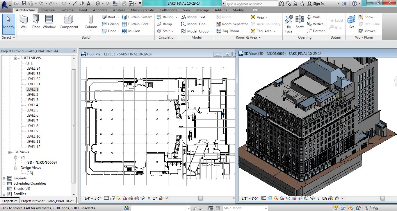
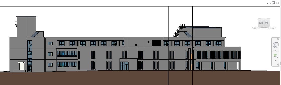
Pointknown / IR Captures and Models NYC Building Icon in Revit
Posted by Jim Foster in 3D, Existing Conditions, New Technologies, Revit on November 25, 2014
Pointknown / IR captured and modeled the Saks 5th Avenue Flagship building over the summer. The building, located at 611 5th Ave NYC, was just refinanced and according to the New York Times valued at $3.7 billion dollars. That’s over $1 billion more than Royal Hudson paid for the entire company last year. The survey and modeling teams used a variety of technologies including LIDAR, its own PKNail Pro and Revit from Autodesk worked throughout the night so not to disturb its clientele and associates. Working through Rob Siegel, now the Design Director at Gensler Pointknown / IR created a full exterior model, shell and cores including the mechanical penthouses. Said Rob, “This is one of the best models we’ve ever seen.”
Pointknown and its sister company IR (interioreview) creates software for the capture and modeling of existing buildings, and provides the same as a service. It uses best in class technologies, whether off the shelf or custom software it designs itself. The companies are entrusted with documenting buildings like Saks 5th Avenue, the Royal Sonesta in New Orleans , academic building on UMass and Phillips Exeter campuses to your home. This December it will be continuing its work as part of the Phase III renovation of the Chicago Hilton. What can we help you with?
*******
Pointknown
support@pointknown.com
617.575.2222
Capture Existing : UMass Old Chapel
Posted by Jim Foster in BIM, Existing Conditions, Revit on September 16, 2014
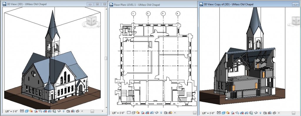 Project : UMass Old Chapel
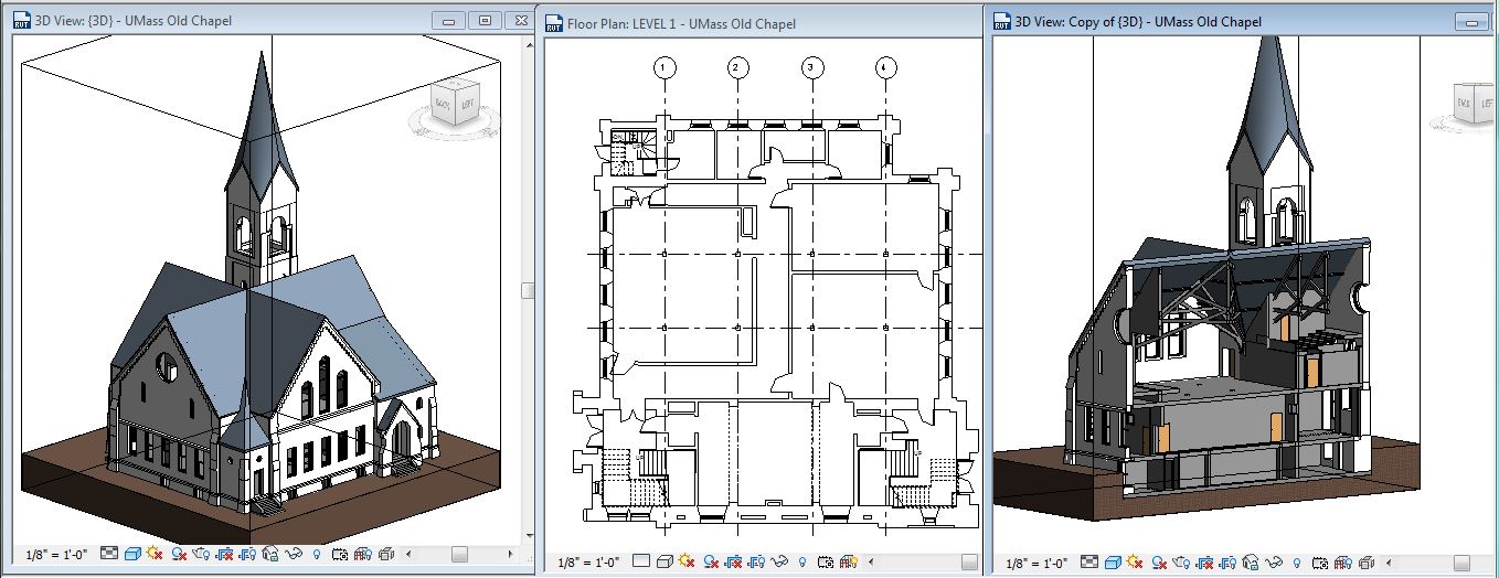
Location : Amherst, MA (University of Massachusetts)
Client : Finegold Alexander
Summary:
Interioreview / PointKnown was hired to survey/document and create an Architectural Revit model using generic components to accurate represent the building. Accurately locate and model interior timbers, chapel and steeple. Include all classrooms and offices.
Technology:
Hardware : Faro 330 : Disto D8
Software: Autodesk Revit : PointKnown PKNail Pro
Process:
Scan and register pointcloud for exterior, chapel and timbers. Import pointcloud to Revit model architectural objects included in the scan. Measure and Build direct to Revit using PKNail Pro, extents of building footprint for quality control to compare with pointcloud data, and measure and model all rooms, offices, and classrooms. Include Kitchen and Bathroom layouts as they occur through out the building using PKNail Pro to place all wall based objects (Toilets, Urinals, Sinks..)
PointKnown Captures Existing Buildings
Software / Services / Consulting
Burns McDonnell Finishes Months Early Using PKNail Pro : Documents 1.5 Million Square Feet Directly In Revit
Posted by Jim Foster in As Builts, BIM, Existing Conditions, Point to Point Laser Technology, Revit on January 30, 2014
 Burns McDonnell was tasked with documenting 40+ buildings totaling more than 1.5 million square feet. The variety of buildings included hospitals, boiler plants, gymnasiums, residences and offices. A total of 8 PKNail Pro licenses were deployed so teams of one could measure and model in real time directly in Revit. The result…
Vicky Borchers, Associate, LEED AP Architectural Production Section Manager
Previously, PointKnown ran a pilot with Burns McDonnell. A single day of training on sight at their offices in Kansas City followed by two days on sight We would be going head to head with another technology documenting different levels of the same building to compare “apples to apples” measuring speed of capture, accuracy, and workflow. Afterwards they would make a decision on which technology to choose. The training went smoothly the first day at their offices and individuals quickly got up to speed utilizing the PKNail Pro interface measuring and modeling directly in Revit from a laser range finder. Once on sight they declared a winner within hours, “Jim wins, everyone on PKNail Pro.”
“There is nothing more efficient out there.”
Steve Cline, Project Manager
Mark Wagner, co-founder of PointKnown. “Having them engage with PKNail at this level allowed us to prove PKNail Pro could handle complex projects easily…plus we were able to make some improvements to the product during the process for our client.”
“Jim and Mark were wonderful to work with implementing the use of PKNail on a large scale project. They have both provided top notch support in a quick and timely fashion. They are always willing to get user input on how to improve the product and will not stop until a resolution is found.”
Jeff Campbell, Senior Application Specialist
Hey Microsoft I’ve Got Your Game Changer; Right Here
Posted by Jim Foster in BIM, New Technologies, Revit on October 24, 2012
 So when we demo our software, inevitably for a lot of architects we are asked, usually at least once, so will this work on the ipad? Fact is, not yet, not until Revit works on the ipad, which the only way I see that happening is that Citrix does an amazing job serving it through a 4G pipeline, so most likely Revit / BIM Models can be viewed in the field, but not yet interacting with one in a meaningful way. Yes you might argue there are check lists, etc. but I’m speaking about dealing with the actual authoring tool. So while architects ask if PKNail Pro works on the ipad. Salespeople will say, “Hey have you seen the Surface? That could be a game changer for you.” That is full blown windows working on a tablet that will run Revit in the field. The review by David Pogue in the Times, states the Surface “On the hardware front, Microsoft has succeeded brilliantly… amazing, amazing hardware. Now the heartbreak: software.” He argues that operating system is not here yet, but this is Windows RT. I’m talking about taking Full Blown Windows into the field for some serious heavy weight mobile application throw down. Building a Revit Model, a Building Information Model of an existing building, in the field, in real time with just your Surface Tablet, a laser range finder, and some software, some industry specific software that will make you 10x faster. Yes, I’m saying PKNail Pro will do that. It’s effective, it’s fast, and now let’s put a wrapper around it named Surface.
So Microsoft, send me a demo, if it’s what I’m expecting I’ll be singing your praises. It’s time to get to work.
*I’m serious Microsoft, so hopefully an identity manager has picked this thread up, or someone wants to make introduction. We are fired up for the Surface and not because we want swag but because it looks like its the size of a beach ball, teed up, and we’re swinging hard.
**Why a picture of LT? Well, it’s LT. Further defined: Left Offensive Tackles are now prized possessions in the NFL and some of the highest paid. That happened when LT lined up. LT changed the game.
New Windows Surface Tablet Puts Revit in the Field.
Posted by Jim Foster in New Technologies, Revit on June 20, 2012
 With Microsoft’s announcement of Windows 8, and the unveiling of the Surface Tablet, it finally appears there will be a tablet form factor that will run Revit in the field. According to the press release there will be two versions, one based on the ARM chip and another based on the Intel i5 chip running Windows 8 Pro. The iPad, as much it is great for so many tasks, simply does not have the horsepower to run Revit in the field, and delivering the type of user experience one would want with heavyweight programs is a real limitation in the ‘cloud.’ I understand Autodesk is now counting solely on Citrix to provide its remote platform but even if you are driving Revit remotely would you want to rely on whatever internet connection you have? That’s just not a funnel I would want to count on in the field.
At first glance you might say so what, not a big deal. However, if I can have a device that toggles between my heavyweight AEC programs, and delivers content the way my my iPad does then I might have an iPad to sell you; because frankly I am sick of devices, I live between the Mac and Windows camp, I’m tired of it. I used to be an Apple fanatic, even being the only kid in business school with a Mac, the disastrous PowerPC model, but what was not to like about Apple. Now, how did we get to the point where Microsoft is the little guy, relatively speaking. Now if they could get their content management into a spot that works the way you want. Imagine the central Revit model up on the sky drive, you check it out in the field, do your work, update it, booyah.
I think single purpose, highly specific apps are great to digest data, not for the creation of it so I am real interested in the melding of tablet like functionality with horsepower. I’m rooting for the little guy, I’m rooting for Microsoft.
********************
BTW anyone else bother to notice the blending and vertical integration of software/hardware. Apple, obviously. Google buys Motorola. Microsoft with multiple attempts, Zune, XBox, etc. and now Surface. And more germane to AEC Trimble buys Tekla and SketchUp. Seems to be the biz strategy du jour, watch for more.
Two great tastes together, Revit and AutoCAD make RevitCAD…
Posted by Jim Foster in BIM, CAD, Revit on November 18, 2011
 So I am just adding to the rumor mill, first started, or first heard by me, by Steve Stafford on his twitter feed, so I’ll throw him under the bus if it does not come to pass that the next release of Revit will be “Revit and AutoCAD glued together in one product called ReviCAD….” There has been a lot of bundling going in the recent years such as buy AutoCAD get Revit with it, etc. but not before has it been under one hood, so interesting if you could use AutoCAD’s drafting tool inside of a Revit view, as I’d like that but how about as a tool to increase migration to Revit, although arguably AutoCAD and Revit lead their fields as CAD drafting and BIM authoring platforms, this doesn’t require anyone to make the leap if it’s true, your just in it. So if true, as those guys in the Guiness commercials would say, “Brilliant.”
BIM Gets Wet : MWH uses Autodesk Suite of Products for Third Set of Panama Locks
Posted by Jim Foster in BIM, Revit on November 15, 2011
 I can’t write it better than the PR folks at Autodesk so excerpts from the Autodesk Press Release copied below.
November 08, 2011 at 8:58 AM
SAN RAFAEL, Calif., Nov. 8, 2011 — Autodesk, Inc. (NASDAQ: ADSK), a leader in 3D design, engineering and entertainment software, announced that MWH Global, a leader in wet infrastructure projects and programs, including water, hydropower and civil infrastructure, has been selected to receive an Autodesk BIM Experience Award. The firm is being honored for using a Building Information Modeling (BIM) process, together with Autodesk BIM software, to help design the Third Set of Locks project for the Panama Canal, intended to double the canal’s shipping traffic capacity.
To help meet the challenges of the project, MWH Global used a BIM process and Autodesk BIM solutions to address the following tasks:
- Autodesk 3ds Max Design software is being used for conceptual and detailed design and was used to produce design visualizations to help the client understand several design options.
- Autodesk Revit Architecture, Autodesk Revit Structure and Autodesk Revit MEPsoftware is being used for detailed design of the canal’s new lock structures, buildings, control towers and a multitude of supporting facilities
- AutoCAD Civil 3D software is helping create more efficient and accurate site designs.
- Autodesk Navisworks Manage software is being used for improved multidiscipline coordination and collaboration, helping resolve design conflicts prior to construction, increasing the quality of the project and helping to prevent costly field changes.
- AutoCAD Electrical software is being used by the electrical subcontractor to MWH Global for the electrical schematics and panel layouts.
- For project handover to the Panama Canal Authority, the team is capitalizing on its use of a BIM workflow to capture asset information such as equipment identification tags for inclusion in an operations manual incorporating project models and data.
Revit Standards : ANZRS has them : Good on ya
Posted by Jim Foster in BIM, Revit, Standards on August 8, 2011
 For everyone who has asked the question about standards from CAD to Revit and beyond and wondered why everyone has their own, and the wasted time documenting it, translating it between companies, etc. well thank ANZRS for taking on this monumental task, and also for those of us standardizing on Revit, thank you for those folks in the Southern Hemisphere, in general for what they are doing in the Revit Head Space.
So is switching or adopting a new or different standard worth the effort? Is it worth documenting and teaching your standards to every single employee that walks through the door when you have a board of smart people documenting and keeping it current if for you? Certainly you need to check it out for yourselves but seems like a no brainer. Thanks ANZRS, good on ya.
Revit Technology Conference : RTC is coming : Down Under or Cali; your pick.
Posted by Jim Foster in Revit on April 15, 2011
Met with Steve Stafford, who has an excellent Revitcentric blog @ http://revitoped.blogspot.com/, the other day in Waltham the other night over a beer, he was in town to talk the mothership about all things Revit in 2012. I gave him a brief preview of PKNail and he was telling me about the Revit Technology Conference, which is kind of like AU but imagine AU where it’s all things Revit. It started down under and because of popular demand and a lot of folks in the industry seeing where the wind is blowing is now in the States for the first time. While those out there who have been living Revit for 5 years and might not feel like it’s cutting edge anymore, it still is, and is still new too many people. Show your Revit chops, hook with other Reviteers, get your game on, get down under or get to Cali, the Revit hordes have arrived.
-
You are currently browsing the archives for the Revit category.
