Archive for category New Technologies
SLAM : A Revolution in Building Surveying & Documentation
Posted by Jim Foster in 3D, BIM, Built Environment, Existing Conditions, New Technologies, Open Engine, SLAM on October 3, 2016
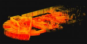 SLAM technology. SLAM, besides sounding rather cools stands for ( Simultaneous Localization and Mapping). And this is is an evolution in the creation of point clouds. Why? SLAM technology allows a user to walk through space, and in essence, create a continuous point cloud of an entire space. Previous technologies require a machine to be placed on a tripod, and continually set up in different locations. To get a full ‘picture’ of whatever you are scanning separate scans have to be ‘stitched’ together, which is not as automated a process as you might imagine. While Leica continues it onslaught of proprietary products and continuous scanning with its Pegasus systems, SLAM is based on open standards and researched extensively through the robotics industry. Off the shelf technology in the form of Hitachi Lasers, Rasberry Pi Processors and the like will start to open up new devices and allow new manufacturers to enter what has been a highly technical and closed field.
While SLAM devices do not have the high fidelity of HDLS, it does allow for some pretty excellent data collection that is typically at a level needed for most building documentation, leaving highly specific / detailed tasks for the more heavyweight scanners, think exposed and extensive MEP, physical plans, historic documentation/reconstruction. Personally, using SLAM devices in combination with our PKNail Pro allows us to move through spaces quickly, efficiently, accurately capturing building geometry with both systems and creating dimensionally accurate Revit objects on the fly with PKNail Pro. This allows us to get in and out of space with minimal interruptions, and allows for quick turn around which is great for building owners/investors through due diligence, BOMA calculations or looking to repurpose/reprogram a building. Recently, we were in and out of 300,000SF of tower in Wilmington Delaware in less than 36 hours.
While SLAM allows for the quick collection of data, interpreting, understanding the data and turning the data into usable documentation still remains very much a craft process. Too many times I have seen a product, such as a Revit model, turned out by groups who fail to understand how building are put together and designed which eventually turns into a product that confuses and confounds the people/architects who need to use it. In the next post I hope to dive into this process vs. product a bit deeper.

Pointknown / IR Captures and Models NYC Building Icon in Revit
Posted by Jim Foster in 3D, Existing Conditions, New Technologies, Revit on November 25, 2014
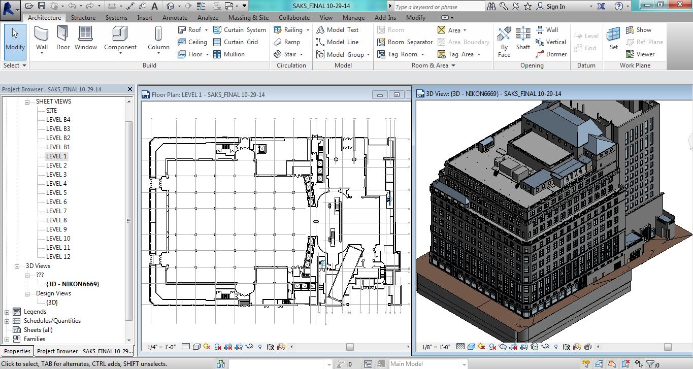
Pointknown / IR captured and modeled the Saks 5th Avenue Flagship building over the summer. The building, located at 611 5th Ave NYC, was just refinanced and according to the New York Times valued at $3.7 billion dollars. That’s over $1 billion more than Royal Hudson paid for the entire company last year. The survey and modeling teams used a variety of technologies including LIDAR, its own PKNail Pro and Revit from Autodesk worked throughout the night so not to disturb its clientele and associates. Working through Rob Siegel, now the Design Director at Gensler Pointknown / IR created a full exterior model, shell and cores including the mechanical penthouses. Said Rob, “This is one of the best models we’ve ever seen.”
Pointknown and its sister company IR (interioreview) creates software for the capture and modeling of existing buildings, and provides the same as a service. It uses best in class technologies, whether off the shelf or custom software it designs itself. The companies are entrusted with documenting buildings like Saks 5th Avenue, the Royal Sonesta in New Orleans , academic building on UMass and Phillips Exeter campuses to your home. This December it will be continuing its work as part of the Phase III renovation of the Chicago Hilton. What can we help you with?
*******
Pointknown
support@pointknown.com
617.575.2222
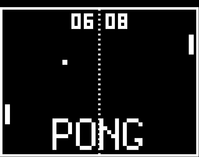
3D Capture and Use : Not even at the Pong Level…..Yet
Posted by Jim Foster in 3D, New Technologies on November 17, 2014
We are still at the bleeding edge of the 3D capture technology. Even though LIDAR has been around since the early 60’s, commercialization of it remains small. Its projected market for 2018 is $515 million. What does that tell me? That’s ridiculously low. For perspective Facebook’s market cap is around $200b, EA Sports, the game producer for ubiquitous gaming technology is around $12b. Those are single companies not an industry. The total market for LIDAR, that is 3D capture of real objects is going to be $515M in 2018. Something else needs to happen to bring 3D to the main stream, and what’s happening now is the introduction of light weight inexpensive 3D sensors from a who’s who of technology companies. A partial list and by no means exhaustive.
- Intel Real Sense Technology
- Project Tango from Google
- Structure io
- Kinect from Microsoft
- Paracosm
- Meta io
- Autodesk 123D Catch
- Acute 3D
- Photosynth
- PrimeSense – Acquired by Apple
And from the way back machine:
Pong, the granddaddy of all video games was arguably the first commercial/consumer success of the gamification of a piece of hardware and its enveloping logic, in the case of pong it was TTL (Transistor – Transistor Logic ). So what’s important to note here is the players now involved in the introduction. Intel, Google, Microsoft, Apple…….. We have the introduction of the hardware and their SDK packs for developers. The next stage will be most interestin; .the software, the games, the apps, the big easy. The other technology beyond these new sensors and LIDAR in most use; photographs. Right now I see in the market a lot of people taking pictures of statues or people, turning them into a 3D Digital object and then maybe printing them out on a 3D printer, I don’t see that as a viable business model, personally I don’t want a 3D printed object of anyone I know and to me it borders on ventriloquist dummy creepiness. However, we need to go through these stages to get to whatever breakthroughs and or commercial successes there will be in the future.
3D printing is moving rapidly, if not into the mainstream, into real uses. The 3D printing market is estimated to be $16.2 billion in 2018 comapred to $2.5 billion in 2013. That is 30x the expected LIDAR market. Why? Companies are printing machine parts (cars, airplanes, etc.) there is movement toward biological printing of food/meat and body parts. So really the mass customization of things where before making one of anything could cost thousands of dollars. I recall prototyping parts through CNC machining or SLA cost at a minimum hundreds of dollars and for bigger parts easily thousands and up. At back to school night this year they had amakerbot set up in the High School lobby and would print out key chains with your initials for a $5 donation. Holy What? Really? How about 3D printing a partial titanium skull to help someone after the original was smashed in an accident. But 5 bucks for a custom printed 3D object?
So what’s the next step in the 3D scanning world now that people can start getting them in their hands for hundreds of dollars, opposed the LIDAR systems that start around $50K. You and your friends scan your house and drop it in as a map pack for Call of Duty. 3D virtual tours of the Louvre. 3D estimating of car damage…….I’m really not sure but I am sure there will be plenty of people working on it. Making the capture and use of 3D easy, that will be the magic trick. Why you might want to is a bigger question. What do I need 3D data for? For real estate? Who is ever going to buy something without physically seeing it. To quote a commercial broker when I was doing some biz dev, “I get them in the car and show it to them…” Remember the broker business is intensely personal so A) they want technology to help them not replace them and B) I am not sure having great 3D imagery is going to sell it. Maybe as part of the tenant fit out allowance they get 3D Design services, or as part of the negotiation you show them what it could look like with their allowance…..I would be really interested in what people think about this subject beyond it’s cool.
****
For something cool, check out the video posted for Mok3 above, Yonald and his cohorts had figured out a way in 2003 to take pictures and turn them into 3D environments., the world is still catching up.
Handheld Scanning for Architecture Gets Real….Google Enters The Picture
Posted by Jim Foster in 3D, New Technologies on March 4, 2014
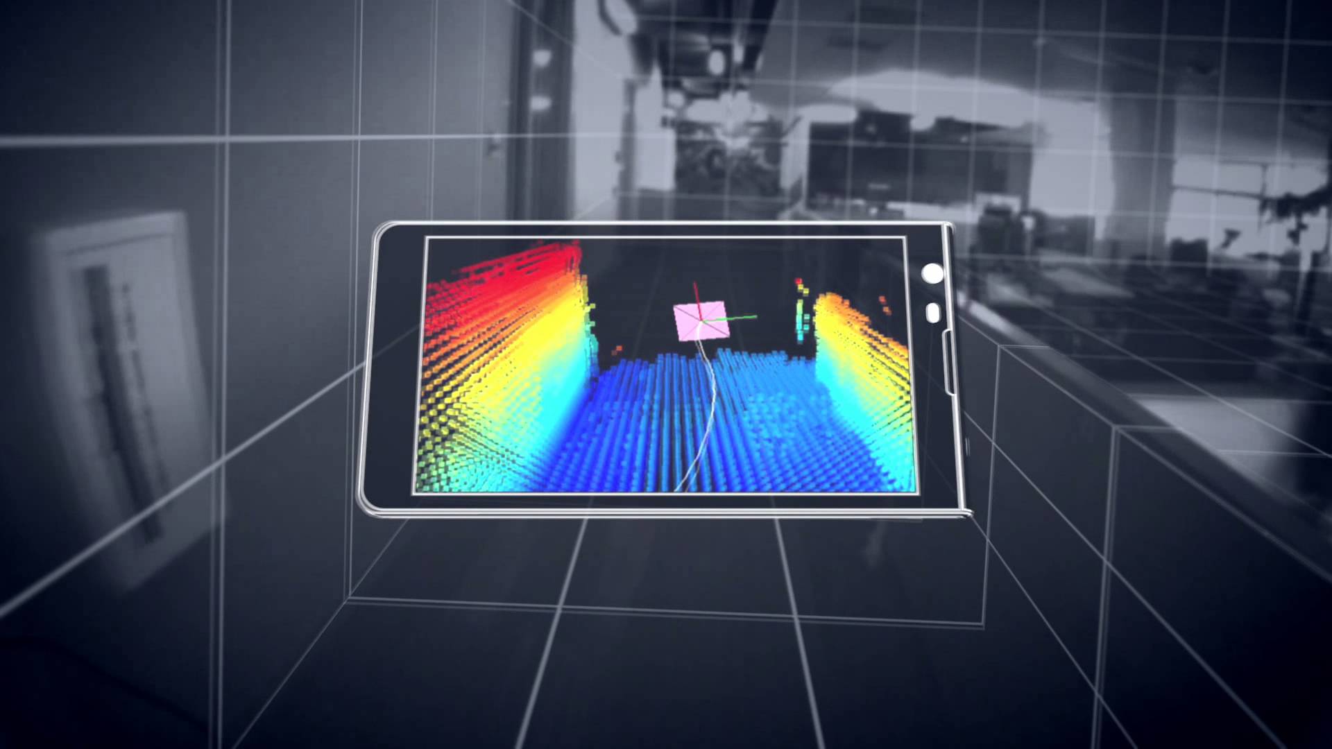 The jigsaw pieces are starting to fill in with google’s Project Tango , and the structure.io sensor. Capturing existing buildings has never been an easy task, as much as the purveyors of existing scanners would like you to believe otherwise. Current laser scanners are expensive and the process was usually too much, too much effort, too much expense for most projects. Additionally, since the entry price was so expensive and each scanner has its own proprietary software, lack of open standards slowed innovation; but here comes handheld devices starting at around $400, and an open source universe that lets a universe of people to start working on current problems. Paracosm working with Project Tango looks like it has come up with a crowd sourced platform to put together fuller models of buildings from multiple people/scanners.
From the videos and data, and although everyone admits it’s early. A regular Joe can walk with a handheld scanning device and capture their world. Allowing for the crowd sourced, user generated 3D mapping of the world. Besides the eery feeling that the Matrix was more prophetic than fiction what can be done with all this cool stuff, what’s next?
It will be in the processing of this data and digestion of it that will make it launch to the next steps. Typically the hurdle of laser scanning is going from scanned data, to data that people can use. Think of scanning this stuff….cool. To floorplans and 3D walk throughs for realtors. So if a realtor can take a $300 handheld scanner, walk around a home or apartment, and have it simply turned into a walk through tour and dimensioned floor plans of a home, excellent. Share those floorplans with a carpet installer for a price, great.
Before scans and point clouds were expensive to attain it looks like the price is about to drop dramatically. Dramatic price drop, easier to attain, increased supply. Increased supply, bigger market. Bigger market, more people. More people, more better. We are just at the start. There will be a lot of companies starting to fill in ways on how to capture and deal with this data and since the world spends about $8 trillion on construction alone there will be room for players. You’re invited.
Deep Analytics Coming to AEC : Data Wants To Be Free. #BIM #XML #AEC
Posted by Jim Foster in BIM, New Technologies on December 16, 2013
 So with Google announcement of Project Genie : Vannevar Technologies and with IBM opening Watson to the programming community one has to believe that deep analytics is coming to the AEC industry. Not silo attempts by industry leaders. It’s got to get easier to run energy analytics, design options, facility management…integrated in a way that is push button easy, and as anyone in the industry can attest we are still far from push button easy. However, getting thousands of people, the collective intelligence of the programming community solving problems. Getting data centralized, performance feedback, learning from that virtuous circle, that is exciting stuff.
Data is the foundation of all of this, without the data, we have nothing to run with. For the AEC environment, it’s the building whether it’s in the design phase, or most likely, already operating. How long will the data reside in proprietary formats? How long is that a viable business model? We will see that companies that can provide the most value with the data start to thrive. Hence the opening up of Watson as a platform and the fact that Google is coming to the AEC marketplace shows there is some seismic shifts in store. I’ve written before that getting the AEC crowd to change their stripes, adopt new technologies, can be difficult, however it’s really going to be Autodesk 360, and what they can offer you in house vs. the world. There has been talk of the ICFxml gbXML or ways to have BIMs in an open environment. This may very well be the tipping point.
Google X : Project Genie : Vannevar Technology -> Wants to Change AEC, Change the World
Posted by Jim Foster in BIM, New Technologies on November 4, 2013
 There seems to be little known about what’s going on at this century’s Xerox PARC, Google X and it’s Project Genie, but a small amount of information was unveiled at ArchDaily. Google’s commitment to sustainability is apparently going to reach into the AEC industry and possibly trample into Autodesk’s campsite. While other software firms are hampered by their own internal growth and sales and what they can commit to marketing, (Autodesk wins there) and R & D. The folks at google, know no such bounds. The spinoff Vannevar Technology (which sounds suspiciously close to Vandelay Industries,) is working on creating…..who knows. Their website states “Reimagining building design for a more sustainable future.” Which is about as exciting as the 5th slide in a time share deck. However, google has the clout and cash in what can be a very stubborn, hesitant to change,” what are you talking to me ” culture. Typically the principals in architecture firms don’t care about technology, they have minions to get it done so why invest in software or new tech when my current pricing, business structure, ROI formulas are working and set in stone, plus I don’t like business that much I like designing building so the less I get involved the better. Engineers will analyze and without comparable metrics to analyze, then…paralyze. Construction managers will embrace tech if it saves the time, which equals money, so time and money but they have to live with the consequences, so embracing new tech….tough crowd. Which is far from saying that things can’t be done better.
The small bit of copy on the web site rightly touts that buildings, yes buildings produce the most greenhouse gases, 40%, so what is google going to do about it? Systems, software, construction methods, materials, vertically integrate and go borg on the industry. My guess is whatever they do, they will be building some buildings with Vannevar Tech for proof of concept and case studies. My guess it’s got be some integrated design and FM system to produce tangible CO2 / greenhouse gas savings, plus energy savings. Some have guessed it might be a SketchUp on steroids, but then why did they sell it to Trimble. And who cares about the design process, what part of that is the current lifecycle of a building, very little, I’d want to own the building for most its life, it’s operating life, and want to own the management of it, and the data. There ya go, so then, IBM and Maixmo, meet google, you might know them. These are the crazy kids floating balloons for internet access. 
3 Myths About Laser Scanning and Point Clouds for Architecture and the Built Environment
Posted by Jim Foster in Built Environment, Laser Scanning, New Technologies, Point Cloud, Point to Point Laser Technology on September 16, 2013

Are laser scanners and their resulting pointclouds right for you and your project? As with all lists, it is simplified and of my opinion. Whether you want to trust my opinion, well that’s up to you, but my company Interioreview has, for over a decade, surveyed / drafted / modeled hundreds of buildings and starting in 2006 delivered Revit Models of existing buildings. My company, PointKnown, has created an Add-In to Revit that allows you capture and model buildings as you measure, in real time with a hand held laser. Now that I’ve blown my own horn here are my top 3 Myths:
It’s Foolproof and Error Free.
Wrong. I have not once received a model from a ‘pointcloud’ surveyor without dimensional errors in the model. Not once. Only because of our internal controls and surveying was I able to call out the errors and was not satisfied with other companies internal controls that the errors would have been found if my company had not found them. Such that we now will do all the modeling in house. Just because someone has a scanner does not mean they do it well.
it is concluded that features such as reflectivity, color, and brightness of the object surfaces have impact on the quality of the data, therefore, although 3D point cloud data is very useful it should be considered that the data can be sometimes irregular and corrupted and thus not exactly reflecting the features of the scanned object.
It’s Easy to Produce a Model From a Pointcloud.
Holy cow, no. How many technologies come into play to get a scan created, consolidated, registered, exported, modeled? First the hardware/scanner, whether it’s from Leica, Faro, whoever, they have their own software to manage the scan/cloud, and then you can export/import to Revit to use as a background to model over. You can use other technologies to help with this process such as Scan to BIM, or to cut portions of the pointcloud you can use ReCap, export to Autocad and re-import that data into Revit, etc. My point being there are a variety of methods to get from here to there but they are not necessarily consistent and have their strength and weaknesses, but you are using human power to make those decisions at each step. And then you are essentially using the pointcloud to ‘trace’ over. That is, you cut sections of the pointcloud in what ever view you are working in and trace over them. Has the person ‘modeling’ the building ever surveyed a building? Or have construction or architecture experience to know how a building should be put together. Does the architect really want to see a wall with a .08 degree deflection of wall off 90 degrees because it will create numerous amount of Revit errors, and was it really there or was the pointcloud interpreted incorrectly? There is no easy button.
It’s Cost Effective
Putting a scanning crew on site for a day is going to cost you between $3K-$4K typically, just to get the exterior of a building, with the pointcloud only, expect at least a 2 day buy in for between $6K and $8K, and that’s typically without going inside, and at the end you get the point cloud, not a Revit model. So a typical house, modeled from a point cloud, inside and out, best guess $8K-$10K. 12 Story Commercial Office Building, $50K+ and so on. Maybe that’s in your budget, but if so why? Why would you need to spend thousands of dollars to be told a room is square and has a 10′ ceiling?
Once dealing with the pointcloud, if you are dealing with it yourself, I hope you have a box/computer that is going to have a minimum of 16GB RAM, multicore XEON processor, etc. and ideally has a solid state drive, this is recommended by Autodesk for ‘pointcloud’ interactions.
You as a consumer of this data need to know what technologies are out there, your choices and their cost. I have seen circumstances and white papers where laser scanning pays dividends many times over, most consistently in existing exposed MEP intensive facilities, think utilities, drilling platforms, power-plants and the like where having a accurate representation of all that data can allow people to retrofit power-plants with few change orders or zero defects. Imagine an offshore construction platform that can lease for $100’s of thousands a day finishing early because of the accuracy of data, very good investment indeed even if it costs $200K to model it accurately. However, do you need that kind of data for a commercial building or an adaptive reuse project? How are you going to capture the interiors? There are methods to capture the built environment accurately for your needs without wasting money and effort.
Conclusion
Start with the simplest model you need, dimensionally accurate, volumetrically correct using whatever technology that gets you there cost effectively and with a level of confidence. Adding details to the model should be done dependent on scope and need. Power-plant of a building, you may want to bring in a scanner to model the piping package, etc. Accuracy of a historic structure that you may need to impact because of a project, sure scan it, but to scan an entire project is overkill in many circumstances no matter what you are told. Scan where you need details added. Know your options. Your tool box needs more than a hammer.
Android Everywhere: Toasters, Robots, and Lasers…The World
Posted by Jim Foster in New Technologies, Open Engine on July 25, 2013
 Sure we want our phone to do everything, make payments, take pictures, unlock our house, turn on the oven….but if you think of all those appliances why don’t they just have a touch screen and create my own button, Jim’s Toast. And if they all can talk to each other, and then tell me when my toast is done. Why have single use buttons at all, why should I go through fifteen menu options to defrost chicken in my microwave, shouldn’t there be an app for that? Even better how about a ‘cook chicken’ app that knows what appliance it is running on and then just does the job of cooking the chicken, microwave, oven, toaster oven, crock pot, doesn’t care.
So why, presumably tackle this, on this blog. In my day to day pitching software as well as services, I get asked in 98% of the meeting, does it run on an ipad, what is your ipad strategy. It starts to sound like the scene when John Malkovich drops into his own brain in the movie “Being John Malkovich” but instead of the word “Malkovich” being spoken as every word, it’s ipad. Listen I got an ipad, it’s great at content and information delivery but as much as I’d like to strap it on to a pair of robot legs and have it run the world, it can’t do everything, and in the AEC profession we still need a set of professional tools, but we can certainly learn from the UI experience of the ipad, and its apps, touch interface etc. And if the iOS was available to stuff on every appliance I’d say iOS everywhere, but it’s not, and Apple long ago made the decision to control their ecosystem. So Android.
Drilling this down into my day to day I use two hand held devices almost everyday, first it’s my phone, and secondly it’s a laser range finder. The phone, while not yet making my toast, does an extraordinary amount of work. My laser, essentially a brick that gives me a critical piece of data. We have software running on a workstation that takes the data and does good things with it, but the laser itself, not so much. However, put Android on the laser the User Experience I can give our clients increases exponentially, or at least geometrically. Instead of looking at a set of single use buttons that we assign sub routines to, we can design an interface that is simplified, elegant, self explanatory. The laser itself becomes the hand held with wifi, bluetooth. You can serve information, query data, use it as a walkie talkie on a job sight, etc. granted your not taking it out on the town at night, but during the day this is it. You put the apps on it that make sense. Need to capture the volume of a room, assign it a room number and move on, boom done. All on the hand held. There is a start to this, with a laser you can strap on the iphone, so somebody is up and thinking, but I don’t have an iphone and the laser/strap on doesn’t have the features and commercial strength I need but on the face of it, great idea.
So Android Everywhere, appliances talking to appliances, cats with dogs, and with Bluetooth Smart Ready, your phone will unlock doors, tell you when your toast is done…just hope google doesn’t serve me an ad after my toast pops up, ‘Wouldn’t You Like Some Smuckers Jam on that Toast”
Great People, Great Pilot: PKNail Pro and Burns McDonnell #BIM #Revit #Existing #Speed
Posted by Jim Foster in BIM, Existing Conditions, New Technologies, Point to Point Laser Technology on July 18, 2013
 Burns McDonnell I was told was tasked with capturing the existing conditions of numerous buildings for the VA. They had first seen PKNail Pro demonstrated at the the KC RUG (Kansas City Revit User Group) by Seiler Instrument and wanted to learn more. I flew down for the pilot on Sunday night. In office training Monday, on site at Leavenworth VA Tuesday and Wednesday. We were to compare two technologies, head to head for capturing existing conditions. I was excited for the opportunity but also to learn about new field technologies, and while I have horse in this race and want it to win, I realize there needs to be more tools for everyone to assist in this often overlooked yet critical task.
Burns had gone through the process of scanning/converting/drafting a Revit model from existing drawing, brought CAD files created from the model to the field, and were running tablets that could take pictures and allow you to draft directly in the CAD so the model could be updated later with that data. My team was running Revit Architecture, PKNail Pro on standard laptops, on a tripod outside, AV cart inside. My team, within the first 90 minutes had created the entire shell of the hospital with customized windows/doors/openings and all floor levels, and within those same 90 minutes the Burns McDonnell team had decided to go with the PKNail Pro.
There is no rocket science involved, there is creating improved work flows, using the right technology, and having the personnel committed to doing the job, with Burns McDonnel we had all three. They had to learn a new technology, incorporate field surveying techniques, and learn a new way to do things. That is a lot to heap on a team in three days, yet they were up and running creating a Revit model, when on Tuesday morning all they had was a blank Revit screen.
I have never claimed PKNail Pro as a cure all for every circumstance, and as a company I have used Pointclouds (more on that later) to capture difficult and hard to reach geometry, but you need to have as many tools at your disposal as possible and I will argue that PKNail Pro that allows you to measure and model directly in the field will give you speed gains you never thought possible.
Thanks Burns McDonnell for the opportunity, and thanks Steve, Vicky, Jeff, Thomas, Mary, Dave and Brian for your work ethic, your hospitality and your willingness to try something new.
Give me a call or email to learn more.
617.575.2222
sales (at) pointknown.com

Reality Capture, for Real. Autodesk Completes Capture of Allpoint Systems : #BIM
Posted by Jim Foster in BIM, Built Environment, New Technologies on February 7, 2013
 At the end of this month Autodesk announced it completed the purchase of Allpoint Systems, this adds to the ‘Reality Capture’ stable now including Alice Labs. Although much like the borg, you google Alice Labs and not much comes up as the technology and seemingly most of the talent has been absorbed into the mothership. As with the purchase of Alice Labs it does not appear that anything from Allpoint will be available for purchase anymore as the technology is incorporated into existing Autodesk products. From the Press Release:
The acquisition of Allpoint Systems reflects Autodesk’s continued investment in developing sophisticated, easy-to-use reality capture technologies. Reality capture is the practice of creating digital models of physical objects and spaces using photography, laser scanning and other technologies.
Why ‘Reality Capture’ or the ‘Documentation of Reality’, well let’s talk about cars, hang with me. According to our good friends at Wikipedia, there are about 254 Million passenger cars on the road or registered in the United States and compared to new car sales of almost 13 million that’s a rough ratio of 80/20, that is new versus used. Interestingly, last time I pulled numbers and the Boston Redevelopment Authority of new construciton permits vs permits for improvements etc. in existing space it was 80/20, in favor of the existing space. So, look where the work is done, used cars, maintenance, improvements, after market, selling gas, same for buildings, infrastructure (bridges, tunnels) etc. And the best way to start a project is to document building, bridges, etc. accurately. The smart money buys used. Or let’s have Autodesk PR Recap. “….continued investment in developing sophisticated, easy-to-use reality capture technologies”
-
You are currently browsing the archives for the New Technologies category.
