Posts Tagged rapid
PointKnown cited in Autodesk Energy Modeling White Paper : BIM
Posted by Jim Foster in 3D, BIM, Built Environment, disto on June 29, 2011
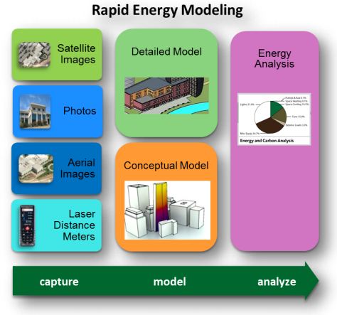
 Autodesk has been concentrating on incorporating their energy modeling tools into their workflow, so much so, they are now calling it Rapid Energy Modeling and have outlined a variety of ways to capture a building’s geometry digitally so you can run it through their energy modeling engines. They outlined the following techniques/methods as the most cost effective for capturing exisitng conditions. Full paper available here: rem_white_paper_2011
Digital photographs
These are photographs of your building taken specifically for rapid energy modeling.
Aerial images
You can download oblique aerial images from Internet sites such as Google Earth or Microsoft®Bing™ mapping services. Alternatively, you can use images from commercial providers of geo-referenced aerial and oblique image libraries such as Pictometry.
Satellite images
Like aerial images, you can download orthogonal images of your building from sites such as Google Earth. RAPID ENERGY MODELING FOR EXISTING BUILDINGS
Laser distance meters
These low-cost laser meters are common surveying tools, and you can also use them onsite to capture key measurements of your building.
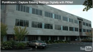
PointKnown was cited as the software to use when utilzing laser range finders and capturing a building in revit.
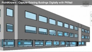
If you plan to capture existing conditions using a laser distance meter, you can use PKNail software from PointKnown (www.pointknown.com) to process those measurements and create a Revit model of your building. By inputting a few simple field measurements PKNail will build a Revit model of the existing structure, in the field, in real time.
This approach involves trained survey personnel that walk around the perimeter of a building and measure key points on the building. The PKNail software utilizes Bluetooth®-enabled laser distance meters to capture dimensional data in the field and send it directly to a laptop loaded with the Revit Architecture or Revit MEP. By capturing data in a specific sequence, the PKNail software creates a Revit model representing the skin of your building as it is being measured.
While we wait for the ‘magic wand’ that digitizes existing buildings while you walk through it, and when I mean digitize, I mean scaled, architectural objects that can be scheduled, processed, etc. more and more technologies are being developed to speed the ‘realty capture’ of buildings. The argument for using PKNail is that the exterior model you build is natively in Revit Architecture and if you want to move inside for interior wall partitioning, etc. for adaptive reuse, etc. you can do that all by utilizing the key pad interface and the laser meter.
Not changing the world just making your day to day a little easier, increase productivity, get more accurate, teeing it up so you can knock it out of the park.
PointKnown Nails It. Rapid Models Autodesk AEC HQ in Waltham: Pilot moves on.
Posted by Jim Foster in 3D, BIM, New Technologies on November 4, 2010
 So some individuals at Autodesk got to see our ‘handcrafted’ videos available at our PKLabs YouTube Channel and got in touch. Ani Deodhar, a Program Manager in their Sustainability Group, explained to me he had a mandate to come up with the best work flows across all of their product lines in order to energy model existing buildings. They have been working on geometry extraction in the labs and anyone who has seen the Photofly demos can attest, this looks very promising. However, our goal with PKNail was always to capture dimensionally correct space and do so with a minimum of software knowledge so PKNail can be leveraged across an organization rather than with a specialized few. I am not knocking any process just pointing out that if you want to move a pallet, for example, it would be nice you could just do it rather than find the guy or gal with the forklift license and then ask them to move it, and then hopefully you get it right the first time. Maybe not the best metaphor but you get it, the more people that can do something, the more of whatever ‘it’ is you can do.
 On site at Autodesk Waltham and using PKNail we were able to survey, measure, build in real time the shell of the building in Revit in less than 3 hours. Then depending on what level of detail, and features you want in the deliverable you may want to spend sometime in the office. However, when we left we knew we had all the key dimensions and information and the model itself was built. This was done at a level needed for energy modeling and we only modeled from the exterior but PKNail allows you to create interior layouts, floor by floor as needed as well. It was then ported through Revit CEA to create an energy analysis of the building.
When creating PKNail we wanted to make things easier on ourselves. The product grew organically from our architectural surveying business. When you’ve repeated the same task enough times, or if you missed a crucial step or measurement that would require you to back to the field, etc. you think there must be a better way. Just like when you make the jump from 2D to 3D you thought, there must be a better way to communicate with my clients, coordinate views, coordinate disciplines, and here it is. Revit is increasingly becoming that better way. Use it however you want, it’s a tool, you can use it communicate visually with your clients if that’s what you need it for or use it to coordinate construction; your choice but it helps. PKNail allows you to quickly and accurately capture existing buildings digitally, either just the exterior for energy modeling or to start your as-built documentation.
On a recent conference call to discuss our pilot with Autodesk, one of the attendees said something like this:
“So you simplified the GUI to automate the tasks you need when surveying and allowed for the wireless capture of data to minimize key stroking”
Well, I don’t know if I would say it exactly like that, but yeah, that’s what we did, and I added that we created a workflow and process that squeezes the surveying knowledge of our organization into the software so people can be a success right out of the box. We wanted to take something simple, point and shoot distance meters, very simple and marry it with something that can be infinitely complex, 3D BIM authoring tools as in Revit, and in turn try to make that simple. Measure a wall/build a wall, window, levels, etc. We call this PPLT (Point to Point Laser Technology). So until we got robots doing this stuff we can never take away the human element from what we do, and so, let’s make just make it easier, faster, better, much like the $6 million dollar man.

