Archive for category Built Environment
SLAM : A Revolution in Building Surveying & Documentation
Posted by Jim Foster in 3D, BIM, Built Environment, Existing Conditions, New Technologies, Open Engine, SLAM on October 3, 2016
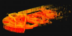 SLAM technology. SLAM, besides sounding rather cools stands for ( Simultaneous Localization and Mapping). And this is is an evolution in the creation of point clouds. Why? SLAM technology allows a user to walk through space, and in essence, create a continuous point cloud of an entire space. Previous technologies require a machine to be placed on a tripod, and continually set up in different locations. To get a full ‘picture’ of whatever you are scanning separate scans have to be ‘stitched’ together, which is not as automated a process as you might imagine. While Leica continues it onslaught of proprietary products and continuous scanning with its Pegasus systems, SLAM is based on open standards and researched extensively through the robotics industry. Off the shelf technology in the form of Hitachi Lasers, Rasberry Pi Processors and the like will start to open up new devices and allow new manufacturers to enter what has been a highly technical and closed field.
While SLAM devices do not have the high fidelity of HDLS, it does allow for some pretty excellent data collection that is typically at a level needed for most building documentation, leaving highly specific / detailed tasks for the more heavyweight scanners, think exposed and extensive MEP, physical plans, historic documentation/reconstruction. Personally, using SLAM devices in combination with our PKNail Pro allows us to move through spaces quickly, efficiently, accurately capturing building geometry with both systems and creating dimensionally accurate Revit objects on the fly with PKNail Pro. This allows us to get in and out of space with minimal interruptions, and allows for quick turn around which is great for building owners/investors through due diligence, BOMA calculations or looking to repurpose/reprogram a building. Recently, we were in and out of 300,000SF of tower in Wilmington Delaware in less than 36 hours.
While SLAM allows for the quick collection of data, interpreting, understanding the data and turning the data into usable documentation still remains very much a craft process. Too many times I have seen a product, such as a Revit model, turned out by groups who fail to understand how building are put together and designed which eventually turns into a product that confuses and confounds the people/architects who need to use it. In the next post I hope to dive into this process vs. product a bit deeper.

Pointknown Wraps Up 18 Tremont : Building Surveying & Documentation : Direct to Revit
Posted by Jim Foster in BIM, Built Environment, Revit on February 8, 2016
We recently delivered a Revit EB (Existing Building) Model of 18 Tremont a historic 12-story, 202,000-square-foot office with ground-floor retail in downtown Boston. The building was acquired by DLJ Real Estate Capital Partners in October 2015. Pointknown, with its partners, created an exterior HDLS (High Definition Laser Scan) and Revit model of the exterior as well as the elevator lobby, and stair cores. After creating the base Revit model the Pointknown Team utilized PKNail Pro , a point to point, direct to Revit, reality capture tool, to document interior wall partitioning, doors, and bathroom layouts. Using the combined technologies helped us tremendously in speed and accuracy, and the database functionality of Revit allowed us to assign spaces/offices and run space calculations a lot easier than polylining spaces. We were then able to produce formatted documents, floor plans, sections, space calculations for the owners / investors and delivered the model for the designers.
Top 3 Issues : Revit Models for Existing Buildings
Posted by Jim Foster in BIM, Built Environment, Existing Conditions, Point to Point Laser Technology on January 19, 2016
Phillips Exeter Academy and Arts Building
In my experience through a dozen plus years of the topic, these issues are best discussed and defined at the outset whether you’re outsourcing the work or doing it yourself.
- What is the initial use of the model?
Start with a MVM (Minimal Viable Model ), volumetrically correct and add detail from there. Interior designers will need different detail than someone implementing CAFM tools, then will an architect adding an addition or an adaptive reuse project. Custom windows, Wall Types, Beams, Fire Protection, Molding, etc. can all be added later so don’t pay for what you don’t need.
- What technology is being deployed?
There are a variety of technologies out there, what are you or your vendor using? How much experience do they have. Do not be afraid to ask for or create a technology road map and ask for demonstrations, experience, and documentation of previous projects. Technology and data capture can be and should be quite different for a 1000 rooms in a hotel vs. a theatre with non-orthogonal walls, balconies, and lots of trim detail. Will it be HDLS (HIgh Def laser Scanning), PPLT (Point to Point Laser Technology or P2P), Photogrammetry, Hand measuring and graph paper? There are price considerations to be had with each.
- Architectural Intent?
Hard to believe this makes into the top 3, however, you need to discuss how you want to deal with non-conforming issues. For example, less than a .3 degree deflection of a wall in plan view will cause +6” over 100 feet. Who cares? Do you? It’s important. As non-ortho connections in Revit cause model errors, something in new construction Revit wants you to avoid, however when modeling existing not every building was built perfectly square. Would you rather see the building modeled with regards to architectural intent and have any non conforming issues annotated or do you want it modeled as it exists.
There is a lot of confusion in the marketplace with regards to laser scanning and modeling existing conditions as there are no standards in place, nor certifying boards for anyone doing this work so until that day happens the onus is on the consumer to ask the questions and help manage the process to get the model they need.
Jim
Co- Founder / CEO Pointknown
Pointknown provides services and software for documenting existing buildings in Revit. We also offer consulting to set up your own projects through enabling technology or project management.
AEC Alliances, Purchases, Cats Living With Dogs
Posted by Jim Foster in Autodesk, BIM, Built Environment, Laser Scanning, Uncategorized on June 16, 2015
 Like a ship that has long passed ripples from Apple’s long held strategy to combine software and hardware has finally come to shore in the AEC marketplace when Autodesk recently announced a ‘collaboration’ with Leica. This shatters their long held belief that they would “never partner with software.” Straight up from the copy on their splash page.
“Smart integration empowers our customers to construct more efficiently and more accurately by making design and reality fit together.”
I have to say this has been a long time coming because if anything Autodesk is excellent at marketing and mostly sort of listening to their customers and marketplace something Leica is beyond woeful at. They are a classic engineering company who makes great products and convinced of their products greatness believe it will have a market. I wonder if they have ever in their existence put together a customer focus group. While Autodesk continues to partner and acquire multiple companies in the 3D and Built Environment space Faro, Leica’s main competitor, acquired Kubit in March. Trimble now owns Tekla, Sketh Up and Gehry Technolgies .
What does the Leica / Autodesk union mean? I would think at least when you need to export point for layout, instead of just picking a generic export you would then export to Leica’s family of products as an option. Perhaps Cloudworx and Recap combination, as I would believe if you are firing up a Leica scanner, their would have to be some link directly to the Autodesk family. Is this friendly oligopoly good for the industry. Well when Windows dominated the marketplace people argues their monopoly was good as it provided a defacto standards, just like Rockefeller argued Standard Oil’s position of owning everything allowed for efficient pricing.
Capture Existing : Chicago Hilton -> Direct to Revit
Posted by Jim Foster in BIM, Built Environment on September 17, 2014
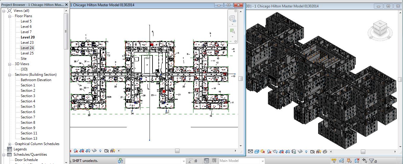
Project : Chicago Hilton
Location : Chicago IL
Client : Hilton Worldwide
Summary:
Interioreview / PointKnown was hired to survey/document 7 Floors of the Chicago Hilton and deliver in 2D .dwg format. Include all rooms, hallways, bathroom fixtures, comm ports, and duplexes, light fixtures, soffits, HVAC Supply and Return.
Technology:
Hardware : Disto D8
Software: Autodesk Revit : PointKnown PKNail Pro : Autocad
Experience:
Over 10 Years Capturing / Modeling / Drafting Existing Conditions
Process:
Survey Common Spaces with PKNail Pro Directly into Revit. Place all hallways, doors, common spaces. Assign spaces/rooms to team members. Measure / Model in real time, placing walls, doors, windows (with correct glass location), wall based objects directly in Revit in real time with PKNail Pro. Wireless Connectivity between workstations allowed instantaneous updates to model and team members. Punch list updated as the property was measured. Team left site with 90% of the model complete. Export Revit to Autocad. QC and line clean up in Autocad. Deliver.
PointKnown Captures The Built Environment
Software | Services | Consulting
What Owners Need to Know When Documenting Existing Buildings ….Part II
Posted by Jim Foster in BIM, Built Environment on September 4, 2014
I recently was invited to present for an IFMA Technology Council Webinar (Link to Deck Here). Both Carlos Vasquez from Epic Scan, the other presenter , and myself had come both mostly to the same conclusions having never met and working on two different coasts. “It really is the wild west out there.” For instance, there are no standards on deliverables or when putting out an RFP for this kind of work. Plus, there are a lot of people out there buying scanners and saying they can do everything that comes in the literature with the hardware. However, owning a piece of hardware and being competent at it are two vastly different things. Just because I own a pair of skates doesn’t mean I can get on the ice with the Rangers. Plus, if the firm you are hiring only has one piece of hardware expect that the quote you get will be one size fits all.
My approach to any given job is to have a detailed conversation with whoever is going to use the Revit Model or Data and what they need it for. For example, an owner doing due diligence on a property has vastly different need and budget then an architectural firm doing an adaptive reuse project on 200,000 SF of Industrial Mill Space. So we tailor the project and technology around their needs and budget. I would argue that an owner look at each project and start with the minimal viable product (MVP) or data set they need and then add details as the project warrants. With that said the base line product should still be solid. For example, we might be asked to come in to verify square footages of a building during due diligence. This is to make certain that the prospective owner has faith that the marketed 100,000 SF actually is 100,000 SF of rentable space. This might just require us to get the shell and cores correctly. But be certain that is done well enough so if going forward we need to add the mechanical plant, or interior partitioning, etc. we have a good foundation to start from.
If you are looking to document your building for almost any stage, due diligence, BOMA calculations, Interior Design, Adaptive Reuse there are a couple of things to keep in mind.
• Size and Complexity of the Project
• Interior/Exterior
• Deadlines and Time Constraints
• Budget and Available Resources
• Uses for Models
and when choosing a vendor or service provider…get references, see if they have done similar projects, ask them about their process and their technology. When done right having a model or your building documented properly, accurately pays dividends many times over, when done wrong it has Excedrin written all over it.
3 Myths About Laser Scanning and Point Clouds for Architecture and the Built Environment
Posted by Jim Foster in Built Environment, Laser Scanning, New Technologies, Point Cloud, Point to Point Laser Technology on September 16, 2013
Are laser scanners and their resulting pointclouds right for you and your project? As with all lists, it is simplified and of my opinion. Whether you want to trust my opinion, well that’s up to you, but my company Interioreview has, for over a decade, surveyed / drafted / modeled hundreds of buildings and starting in 2006 delivered Revit Models of existing buildings. My company, PointKnown, has created an Add-In to Revit that allows you capture and model buildings as you measure, in real time with a hand held laser. Now that I’ve blown my own horn here are my top 3 Myths:
It’s Foolproof and Error Free.
Wrong. I have not once received a model from a ‘pointcloud’ surveyor without dimensional errors in the model. Not once. Only because of our internal controls and surveying was I able to call out the errors and was not satisfied with other companies internal controls that the errors would have been found if my company had not found them. Such that we now will do all the modeling in house. Just because someone has a scanner does not mean they do it well.
it is concluded that features such as reflectivity, color, and brightness of the object surfaces have impact on the quality of the data, therefore, although 3D point cloud data is very useful it should be considered that the data can be sometimes irregular and corrupted and thus not exactly reflecting the features of the scanned object.
It’s Easy to Produce a Model From a Pointcloud.
Holy cow, no. How many technologies come into play to get a scan created, consolidated, registered, exported, modeled? First the hardware/scanner, whether it’s from Leica, Faro, whoever, they have their own software to manage the scan/cloud, and then you can export/import to Revit to use as a background to model over. You can use other technologies to help with this process such as Scan to BIM, or to cut portions of the pointcloud you can use ReCap, export to Autocad and re-import that data into Revit, etc. My point being there are a variety of methods to get from here to there but they are not necessarily consistent and have their strength and weaknesses, but you are using human power to make those decisions at each step. And then you are essentially using the pointcloud to ‘trace’ over. That is, you cut sections of the pointcloud in what ever view you are working in and trace over them. Has the person ‘modeling’ the building ever surveyed a building? Or have construction or architecture experience to know how a building should be put together. Does the architect really want to see a wall with a .08 degree deflection of wall off 90 degrees because it will create numerous amount of Revit errors, and was it really there or was the pointcloud interpreted incorrectly? There is no easy button.
It’s Cost Effective
Putting a scanning crew on site for a day is going to cost you between $3K-$4K typically, just to get the exterior of a building, with the pointcloud only, expect at least a 2 day buy in for between $6K and $8K, and that’s typically without going inside, and at the end you get the point cloud, not a Revit model. So a typical house, modeled from a point cloud, inside and out, best guess $8K-$10K. 12 Story Commercial Office Building, $50K+ and so on. Maybe that’s in your budget, but if so why? Why would you need to spend thousands of dollars to be told a room is square and has a 10′ ceiling?
Once dealing with the pointcloud, if you are dealing with it yourself, I hope you have a box/computer that is going to have a minimum of 16GB RAM, multicore XEON processor, etc. and ideally has a solid state drive, this is recommended by Autodesk for ‘pointcloud’ interactions.
You as a consumer of this data need to know what technologies are out there, your choices and their cost. I have seen circumstances and white papers where laser scanning pays dividends many times over, most consistently in existing exposed MEP intensive facilities, think utilities, drilling platforms, power-plants and the like where having a accurate representation of all that data can allow people to retrofit power-plants with few change orders or zero defects. Imagine an offshore construction platform that can lease for $100’s of thousands a day finishing early because of the accuracy of data, very good investment indeed even if it costs $200K to model it accurately. However, do you need that kind of data for a commercial building or an adaptive reuse project? How are you going to capture the interiors? There are methods to capture the built environment accurately for your needs without wasting money and effort.
Conclusion
Start with the simplest model you need, dimensionally accurate, volumetrically correct using whatever technology that gets you there cost effectively and with a level of confidence. Adding details to the model should be done dependent on scope and need. Power-plant of a building, you may want to bring in a scanner to model the piping package, etc. Accuracy of a historic structure that you may need to impact because of a project, sure scan it, but to scan an entire project is overkill in many circumstances no matter what you are told. Scan where you need details added. Know your options. Your tool box needs more than a hammer.
86% of Building Construction Expenditures Relate to Renovation of Existing Buildings
Posted by Jim Foster in BIM, Built Environment, economic trends, Energy Analysis, Green, Sustainable Retrofits on February 18, 2013
 “As ASHRAE President Gordon V.R. Holness noted in the ASHRAE Journal, “Approximately 86% of building construction expenditures relate to renovation of existing buildings, not to new construction.” Holness estimated that “over the next 30 years about 150 billion sf of existing buildings (roughly half of the entire building stock in the United States) will need to be renovated.” Historically, new construction only adds about 2% annually to the U.S. commercial building stock, so the real opportunities for reducing operating costs must be found in building retrofit and renovation.” – Glumac Blog.
Buildings are the major source of global demand for energy and materials that produce by-product greenhouse gases (GHG). Slowing the growth rate of GHG emissions and then reversing it is the key to addressing climate change and keeping global average temperature below 2°C above pre-industrial levels.
To accomplish this, Architecture 2030 issued The 2030 Challenge asking the global architecture and building community to adopt the following targets:
- All new buildings, developments and major renovations shall be designed to meet a fossil fuel, GHG-emitting, energy consumption performance standard of 60% below the regional (or country) average/median for that building type.
- At a minimum, an equal amount of existing building area shall be renovated annually to meet a fossil fuel, GHG-emitting, energy consumption performance standard of 60% of the regional (or country) average for that building type.
- The fossil fuel reduction standard for all new buildings and major renovations shall be increased to:
- 70% in 2015
- 80% in 2020
- 90% in 2025
- Carbon-neutral in 2030 (using no fossil fuel GHG emitting energy to operate).
These targets may be accomplished by implementing innovative sustainable design strategies, generating on-site renewable power and/or purchasing (20% maximum) renewable energy.
Please visit Frequently Asked Questions section for more in-depth information on the 2030 Challenge.
******
*Note: This was stated in the January 2008 Edition of the ASHRAE Journal. When we polled permitting for Boston, we found 75% for construction in Existing Buildings. 25% New.
Reality Capture, for Real. Autodesk Completes Capture of Allpoint Systems : #BIM
Posted by Jim Foster in BIM, Built Environment, New Technologies on February 7, 2013
 At the end of this month Autodesk announced it completed the purchase of Allpoint Systems, this adds to the ‘Reality Capture’ stable now including Alice Labs. Although much like the borg, you google Alice Labs and not much comes up as the technology and seemingly most of the talent has been absorbed into the mothership. As with the purchase of Alice Labs it does not appear that anything from Allpoint will be available for purchase anymore as the technology is incorporated into existing Autodesk products. From the Press Release:
The acquisition of Allpoint Systems reflects Autodesk’s continued investment in developing sophisticated, easy-to-use reality capture technologies. Reality capture is the practice of creating digital models of physical objects and spaces using photography, laser scanning and other technologies.
Why ‘Reality Capture’ or the ‘Documentation of Reality’, well let’s talk about cars, hang with me. According to our good friends at Wikipedia, there are about 254 Million passenger cars on the road or registered in the United States and compared to new car sales of almost 13 million that’s a rough ratio of 80/20, that is new versus used. Interestingly, last time I pulled numbers and the Boston Redevelopment Authority of new construciton permits vs permits for improvements etc. in existing space it was 80/20, in favor of the existing space. So, look where the work is done, used cars, maintenance, improvements, after market, selling gas, same for buildings, infrastructure (bridges, tunnels) etc. And the best way to start a project is to document building, bridges, etc. accurately. The smart money buys used. Or let’s have Autodesk PR Recap. “….continued investment in developing sophisticated, easy-to-use reality capture technologies”
5 Firms Converge on New Orleans to Document The Royal Sonesta
Posted by Jim Foster in 3D, As Builts, BIM, Built Environment, Existing Conditions on January 16, 2013
 “Jim your a go….” 2:40 PM, New Years Eve 2012. Text from our client; Mark at Looney & Associates
Our work window was January 3rd through January 9 2013. Travel arrangements and team needed to be assembled for flights in two days. The only thread holding this together was PKNail Pro.
Team members included individuals from Langan Engineering, Turis, TrueScan3d, LandAir Surveying and my company Interioreview. The Job: Survey and Document Floors 2-7 of the Royal Sonesta Hotel, 300 Bourbon Street. Include structure, electrical objects (Duplex, Com Ports, Thermostats, Wall Lights, etc) and Fire Protection. 450+ Rooms, Common Spaces, Administrative Spaces, +200,000 SF. 1 Week. From Blank Screen to Floorplans and RCP.
“This is innovative stuff…”, Greg Jensen, Langan Engineering
“…Boom, your done.” Brady O’Brien, Turis Systems
“This certainly opens the door for future teaming efforts, and we’ve already begun to push PK Nail on some of our interior projects – integrating it with scanning and traditional survey.” – Paul Fisher, VP Langan Engineering.
This project could not have happened without the participating firms willingness to deal with such a tight deployment deadline and with the excellent individuals that arrived in New Orleans. It also could not have happened, and I do have a horse in this race, without PKNail Pro and Revit. There was simply no other way to coordinate multiple personnel field surveying without both. We were able to deploy resources as needed since everything was being surveyed and modeled in real time. 4th Floor, South Wing, Greg get on it. Brian, 2nd Floor with Nico etc. This also allowed us to create a punch list in real time. Reflected Ceiling on 3rd Floor, etc. as all the files were compiled daily, if not more often into a central file. Although the deliverable will eventually be in 2D Autocad, all the initial documentation will be in Revit, so even though it was not part of the scope, we will be able to deliver a typical section through the building with only a small post processing effort.
Lastly, thank you to the good folks at The Royal Sonesta, New Orleans for treating us so well. They understand hospitality and have a great team.
More and more firms are relying on PKNail Pro for documenting buildings whether they need the final deliverable in Revit or 2D Autocad. PKNail Pro can deliver.
-
You are currently browsing the archives for the Built Environment category.
