Posts Tagged Laser Scanning
Pointknown Wraps Up 18 Tremont : Building Surveying & Documentation : Direct to Revit
Posted by Jim Foster in BIM, Built Environment, Revit on February 8, 2016
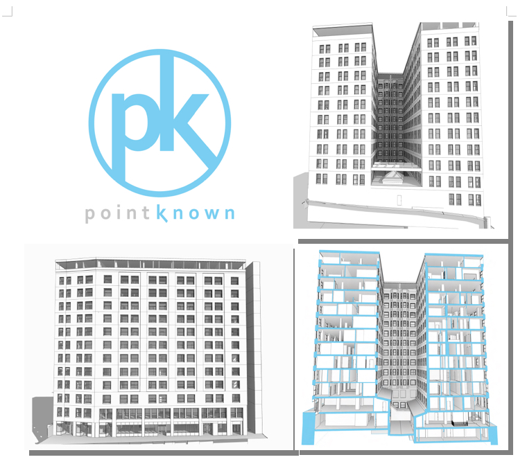
We recently delivered a Revit EB (Existing Building) Model of 18 Tremont a historic 12-story, 202,000-square-foot office with ground-floor retail in downtown Boston. The building was acquired by DLJ Real Estate Capital Partners in October 2015. Pointknown, with its partners, created an exterior HDLS (High Definition Laser Scan) and Revit model of the exterior as well as the elevator lobby, and stair cores. After creating the base Revit model the Pointknown Team utilized PKNail Pro , a point to point, direct to Revit, reality capture tool, to document interior wall partitioning, doors, and bathroom layouts. Using the combined technologies helped us tremendously in speed and accuracy, and the database functionality of Revit allowed us to assign spaces/offices and run space calculations a lot easier than polylining spaces. We were then able to produce formatted documents, floor plans, sections, space calculations for the owners / investors and delivered the model for the designers.

3 Myths About Laser Scanning and Point Clouds for Architecture and the Built Environment
Posted by Jim Foster in Built Environment, Laser Scanning, New Technologies, Point Cloud, Point to Point Laser Technology on September 16, 2013
Are laser scanners and their resulting pointclouds right for you and your project? As with all lists, it is simplified and of my opinion. Whether you want to trust my opinion, well that’s up to you, but my company Interioreview has, for over a decade, surveyed / drafted / modeled hundreds of buildings and starting in 2006 delivered Revit Models of existing buildings. My company, PointKnown, has created an Add-In to Revit that allows you capture and model buildings as you measure, in real time with a hand held laser. Now that I’ve blown my own horn here are my top 3 Myths:
It’s Foolproof and Error Free.
Wrong. I have not once received a model from a ‘pointcloud’ surveyor without dimensional errors in the model. Not once. Only because of our internal controls and surveying was I able to call out the errors and was not satisfied with other companies internal controls that the errors would have been found if my company had not found them. Such that we now will do all the modeling in house. Just because someone has a scanner does not mean they do it well.
it is concluded that features such as reflectivity, color, and brightness of the object surfaces have impact on the quality of the data, therefore, although 3D point cloud data is very useful it should be considered that the data can be sometimes irregular and corrupted and thus not exactly reflecting the features of the scanned object.
It’s Easy to Produce a Model From a Pointcloud.
Holy cow, no. How many technologies come into play to get a scan created, consolidated, registered, exported, modeled? First the hardware/scanner, whether it’s from Leica, Faro, whoever, they have their own software to manage the scan/cloud, and then you can export/import to Revit to use as a background to model over. You can use other technologies to help with this process such as Scan to BIM, or to cut portions of the pointcloud you can use ReCap, export to Autocad and re-import that data into Revit, etc. My point being there are a variety of methods to get from here to there but they are not necessarily consistent and have their strength and weaknesses, but you are using human power to make those decisions at each step. And then you are essentially using the pointcloud to ‘trace’ over. That is, you cut sections of the pointcloud in what ever view you are working in and trace over them. Has the person ‘modeling’ the building ever surveyed a building? Or have construction or architecture experience to know how a building should be put together. Does the architect really want to see a wall with a .08 degree deflection of wall off 90 degrees because it will create numerous amount of Revit errors, and was it really there or was the pointcloud interpreted incorrectly? There is no easy button.
It’s Cost Effective
Putting a scanning crew on site for a day is going to cost you between $3K-$4K typically, just to get the exterior of a building, with the pointcloud only, expect at least a 2 day buy in for between $6K and $8K, and that’s typically without going inside, and at the end you get the point cloud, not a Revit model. So a typical house, modeled from a point cloud, inside and out, best guess $8K-$10K. 12 Story Commercial Office Building, $50K+ and so on. Maybe that’s in your budget, but if so why? Why would you need to spend thousands of dollars to be told a room is square and has a 10′ ceiling?
Once dealing with the pointcloud, if you are dealing with it yourself, I hope you have a box/computer that is going to have a minimum of 16GB RAM, multicore XEON processor, etc. and ideally has a solid state drive, this is recommended by Autodesk for ‘pointcloud’ interactions.
You as a consumer of this data need to know what technologies are out there, your choices and their cost. I have seen circumstances and white papers where laser scanning pays dividends many times over, most consistently in existing exposed MEP intensive facilities, think utilities, drilling platforms, power-plants and the like where having a accurate representation of all that data can allow people to retrofit power-plants with few change orders or zero defects. Imagine an offshore construction platform that can lease for $100’s of thousands a day finishing early because of the accuracy of data, very good investment indeed even if it costs $200K to model it accurately. However, do you need that kind of data for a commercial building or an adaptive reuse project? How are you going to capture the interiors? There are methods to capture the built environment accurately for your needs without wasting money and effort.
Conclusion
Start with the simplest model you need, dimensionally accurate, volumetrically correct using whatever technology that gets you there cost effectively and with a level of confidence. Adding details to the model should be done dependent on scope and need. Power-plant of a building, you may want to bring in a scanner to model the piping package, etc. Accuracy of a historic structure that you may need to impact because of a project, sure scan it, but to scan an entire project is overkill in many circumstances no matter what you are told. Scan where you need details added. Know your options. Your tool box needs more than a hammer.
Misconception of Laser Scanning & BIM Creation : #BIM
Posted by Jim Foster in BIM, Laser BIM, Laser Scanning on August 26, 2009
Quick post from Lidar News about how there is a misconception happening across the real estate community that laser scanning creates a BIM model. Awesome spatial database, yes. BIM model, no. Still a lot of work to do that.
Point to Point to Laser Technology (PPLT) can help create BIMs in the field.
